What to Know
- A First Alert is in effect through 10 a.m. Saturday due to a major coastal storm.
- A man was killed when a 45-foot tree crushed his car along a Montgomery County road.
- The storm knocked out power to more than half a million customers across eastern Pennsylvania, New Jersey and Delaware.
A powerful winter storm slammed the Philadelphia region on Friday packing 70 mph winds and heavy snow, creating treacherous travel conditions that led to the death of one person, stranded scores of travelers, and knocked out power to a half-million electric customers.
Howling winds left a path of destruction across the region felling trees onto power lines and ripping apart buildings. A wind gust of 71 mph was recorded in Cape May, New Jersey Friday afternoon. Inland, in Washington Township, Gloucester County, 65 mph winds were recorded. Across the Delaware River, in Philadelphia, winds topped out at 62 mph. (Here's the latest snow totals and wind gust highs per neighborhood.)
Trees began falling in the late morning, adding to a mounting number of hazards as the day progressed.
Now in Wind Gap, Northampton County. Rain switched to snow fast and now it’s constant snow coming down. @NBCPhiladelphia pic.twitter.com/nyYYlrOAXp
— Steven Fisher (@Steven_Fisher10) March 2, 2018
A 57-year-old man was killed when a 45-foot tree crashed down onto his car along S. Gulph Road near Arden Road in Upper Merion at 7 p.m. Friday, township police said. The tree crushed the windshield, dashboard and front seats.
In one of the more jarring images, a tree fell onto a SEPTA bus traveling west on Interstate 76. The westbound lanes were shut down shortly after 1 p.m. and remained at a standstill through the afternoon, state police said. Four of the 15 passengers were injured.

Branches that landed on power lines sparked fires at homes in Cherry Hill, New Jersey and in Havertown, Pennsylvania. The heavy arms of a huge tree crashed into a child's room along Rhyle Lane in Bala Cynwyd leaving extensive damage. No one was injured in any of the incidents. But many similar scenes across the area left first responders scrambling to keep up with calls for help.
The storm knocked out power to more than 522,000 customers across southeastern Pennsylvania, New Jersey and Delaware. It could be four days for some customers before the electricity is turned back on.
Blizzard conditions were reported in the Poconos after hours of sustained winds and snow. Sloppy, wet snow left some highways and roads impassable in Philadelphia and the surrounding suburbs. Some drivers reported spending hours on Route 309 near Perkasie. In other spots, drivers bailed on their cars when they became stuck in the snow.
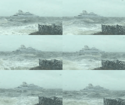
Amtrak suspended all services along the Northeast corridor line from Washington to Boston just before 1 p.m. due to weather-related issues. The Cape May-Lewes Ferry shut down at 1 p.m. for the rest of the day, but was expected to operate normally again Saturday.

Most of SEPTA's Regional Rail lines were suspended by 3 p.m. Passengers left in limbo packed Center City stations. Travelers to and from Philadelphia International Airport also found themselves stranded. More than 400 flights were cancelled as of 4 p.m. Some arrivals were diverted to other airports. At 5 p.m., American Airlines suspended all flights at PHL for the rest of Friday.
Local
Breaking news and the stories that matter to your neighborhood.
PHOTOS: Major Storm Brings Damaging Wind, Rain and Snow to Area
Dozens of schools decided to close early or cancel after school activities.
At the Jersey Shore, wind gusts ripped huge wall sections off of the shuttered Trump Plaza casino along the Atlantic City Boardwalk. Conerns turned to coastal flooding late Friday as the storm coupled with a full moon was expected to bring high waters on Saturday.
In the Lehigh Valley and upper suburbs, several inches of snow piled up as high winds sent flakes flying sideways.
TIMING FOR REST OF STORM
This weather event will last at least 36 hours and conditions will vary depending on what part of the area you're in. Here's a breakdown:
Saturday
The center of the storm will sit offshore producing high winds in combination with the full moon and high tide, leading to a coastal flood threat on Saturday for parts of the Jersey Shore and Delaware beaches.
The flood waters will likely make some streets and causeways impassable. Remember it's impossible to know how deep standing water is, so never drive through it.
STORM IMPACTS
Dangerous & Destructive Winds
What: 50 to 70 mph wind gusts
When: Noon Friday to 10 a.m. Saturday
Where: Entire area — with highest gusts at the shore points, inland South Jersey, and Southern Delaware
Impacts: Widespread power outages anticipated; downed trees, billboards, canopies, and light poles; air travel disruptions
Coastal Flooding at High Tide With a Full Moon
What: 6 to 10 foot waves at the beach; 20 to 25 foot waves at sea (Hurricane Force winds at sea)
When: 9 to 11 a.m. Saturday and 9 to 11 p.m. Saturday
Where: All shore areas in New Jersey and Delaware
Impacts: Roads covered with water
By mid-morning Friday South Shore Road and Ohio Avenue in Absecon were closed due to flooding. Route 35 in Brick and Belmar also were experiencing some flooding, with intermittent closures of one of the highway's two lanes.
The storm could take a chunk out of Jersey shore beaches that are still being repaired following damage from previous storms. There's no guarantee that all the sand that washes away over the next few days will be replaced.
Heavy Snow and Possible Blizzard Warnings
What: 6 to 12 inches of snow with winds above 40 mph
When: Friday
Where: Southern Poconos
Impact: Low visibility and dangerous travel
Whiteout Conditions
What: Blowing wet snow combined with sustained winds of 30 to 40 mph and gusts of 50 to 60 mph could cause whiteout conditions
When: Friday afternoon, evening
Where: Lehigh Valley, Pennsylvania suburbs, Philadelphia, South Jersey, Northern Delaware
Impact: Low visibility, dangerous travel and possible travel delays for air and mass transit
Flooding From Heavy Rains
What: 1 to 2 inches of rain
When: Through noon Friday
Where: Lehigh Valley; Philadelphia suburbs; South Jersey
Impact: Slippery roads; localized road flooding
Stay with NBC10 and download the free NBC10 app for the latest First Alert Weather updates.


