
What to Know about coastal winter storm
- A winter storm bringing snow and rain began moving through the Philadelphia region and surrounding suburbs on Saturday.
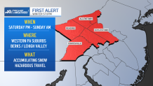
- The storm arrived midday Saturday. A First Alert is in effect into Sunday morning for the colder Pennsylvania suburbs, Berks County and the Lehigh Valley.
- Be sure to keep checking back with NBC10 News on air, online and in our app for the latest storm tracks, snow/rain predictions and timing.
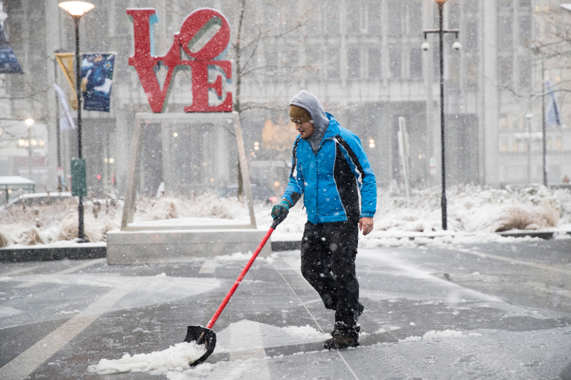
The first significant snow in about two years hit parts of the Philadelphia region on Saturday, however, it isn't expected to snow everywhere as some places get some sleet before it changed over to just rain.
The NBC10 First Alert Weather Team issued a First Alert for accumulating snow and hazardous travel for the western Pennsylvania suburbs, Berks County and the Lehigh Valley from Saturday afternoon into Sunday morning.
For a full list of snow totals in our region, click here.
Get Philly local news, weather forecasts, sports and entertainment stories to your inbox. Sign up for NBC Philadelphia newsletters.
What’s the timing of the storm?
The storm system moved across the area around noon. Many locations from the New Jersey Turnpike and points West, began as snow. The Jersey Shore and Delaware Beaches started as rain, and remained rain for the duration of the storm with temperatures well into the 40’s. For Philadelphia and the immediate suburbs, snow began falling in the early afternoon. The snow eventually mixed with and changed to rain. Temperatures will warm to the upper 30’s.
How much snow will fall in our region?
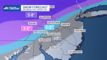
As much as an inch of snow could fall in and around Philadelphia but the rain will quickly wash away any accumulations. For the Northwestern Suburbs of Philadelphia – including Northern Chester, Western Montgomery, and Upper Bucks Counties – snow will fall into the early evening and accumulate as much as two to four inches. A change to rain is likely after 6 p.m. for these locations.
For the Lehigh Valley, snow began mid-afternoon, and it will accumulate fairly quickly. Berks, Lehigh, and Northampton counties are likely to see as much as four to seven inches of snow. The worst of the storm will arrive for the Lehigh Valley in and around the early to middle part of the evening. Elevations over 500 feet will see the highest snow totals, while valleys will see lower amounts. A brief change to sleet or freezing rain is possible in parts of the Lehigh Valley, which would cut down totals a bit.
The storm will begin to wrap up by the early morning hours on Sunday. It is possible that some areas with rain will end as a brief period of snowfall, but no additional accumulations are expected. For Sunday, passing flurries are possible during the day, with a mostly cloudy sky. A gusty breeze will make it feel cooler, with highs in the middle and upper 30’s.
When was the last time we had significantly measurable snow in Philadelphia?
The storm will exit the area by early Sunday morning, and lingering flurries are possible into Sunday afternoon. Now is the time to plan ahead for the first significant winter storm in two seasons as Philly could break its longest snowless streak on record.
Philadelphia last had measurable snow on Feb. 1, 2023, when a meager 0.3 of an inch fell.
The last times Philly got snow
The last time Philadelphia got more than an inch of snow was more than 700 days ago! On Jan. 29, 2022, 5.8 inches of snow fell in Philadelphia, which helped the total snowfall for that storm at Philadelphia International Airport top out at 7.5 inches. Since then, Philly hasn’t seen more than an inch of snow on any day.
Sign up for our Breaking newsletter to get the most urgent news stories in your inbox.
That same January 2022 storm left nearly 2 feet of snow in parts of New Jersey.
Now is the time to prepare for the storm
Road crews and emergency officials have spent days getting ready for whatever falls from the sky.
With the storm moving in, you should take steps now if you haven't already. Dig out the snow shovel and ice melt, grab that ice scraper and put it in your car, make sure to clear out gutters (that can even help if it rains) and potentially grab your sled out of the basement.
Here's the full checklist to make sure you're ready for whatever this storm brings:
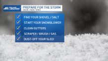
As for your car, make sure you have your tires inflated and plenty in the trunk, including some extra windshield wiper fluid and kitty litter.
Also, emergency management in the Pennsylvania suburbs suggests drivers be weary of slick roads and have their devices charged up so they won't be left in the dark if stranded or if they lose power.
Flooding concerns
While snow is often the focus of any winter storm, there is a chance for excessive rainfall from this storm. That could lead to localized flooding -- especially along streams, rivers and along the coast.
The greatest flood threats are from the I-95 corridor into South Jersey and Delaware, where mostly rain is expected.
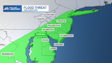
We have been saturated with a lot of rain recently, which adds to the threat. Add in an expected rainstorm in the middle of next week, and flooding remains a concern.
Going to the Eagles-Giants game in North Jersey?
Don't expect a snow game at MetLife Stadium. Showers should taper off around the 4:25 p.m. kickoff at the Meadowlands, if not before.
Stay ahead of the storm with NBC10
Be sure to have your phone and other devices charged up with the latest version of the NBC10 app downloaded. We will have updated forecast, snow projections and live interactive radar leading up to and during the winter storm online and on air.
