
What to Know
- Keep the shovels and ice melt handy as Friday is expected to be snowy.
- We have issued a First Alert for accumulating snow leading to tricky travel for the entire region.
- Several inches of snow could fall across neighborhoods in the region. Some places could get half a foot.
Editor's Note (Jan. 19, 2024, 8:09 a.m.): This story is no longer being updated. For the latest on the Friday snow as it falls, click here.
Here we snow again in Pennsylvania, New Jersey and Delaware!
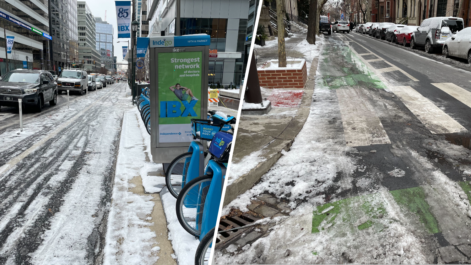
As the Philadelphia region continues to deal with slippery sidewalks and icy spots on roads left by the snow that fell Monday night into Tuesday morning, another blast of snow is expected to bring more tricky travel on Friday. Half a foot of snow could fall in some neighborhoods, while places nearby could see just a few inches.
Get Philly local news, weather forecasts, sports and entertainment stories to your inbox. Sign up for NBC Philadelphia newsletters.
The NBC10 First Alert Weather Team has issued a 🚨 First Alert 🚨 for accumulating snow leading to slippery conditions and travel delays for the entire area from South Jersey to the Lehigh Valley on Friday, Jan. 19, 2024.
Philadelphia, Wilmington and surrounding suburbs are under a winter storm warning.
Here's what to know about the timing and impacts of the snow:
When did the snow start? ❄️
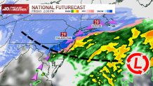
An area of low pressure moved across the Ohio Valley and transferred some energy to a coastal low that wdeveloped off the Mid-Atlantic coast during the day on Friday. This brought snow to our region.
You might not get consistent snowfall at the start of this one, but snow should be falling as the day goes on.
The first snow showers moved in around 5 a.m., as flakes were reported in Wilmington, Delaware. by 5:45, some flakes were falling in Philly. By 6:30 a.m., the snow fell steady in King of Prussia. Before daybreak, snow was falling throughout much of the region.
The snowfall becomes steady as the morning goes on and continues to be steady into the afternoon. During the afternoon parts of the region could get some heavier snowfall.
The snow is expected to taper off during the evening.

Unlike the Monday to Tuesday storm where a wintry mix and ice fell onto snow, this is expected to be mostly a snow event in most neighborhoods. The exceptions will be near the Delaware and New Jersey coasts where some rain and ice should mix in and limit snowfall the closer you are to the water.
How much snow is expected to fall? Get estimated snow totals ❄️
Keep the snow brushes and shovels handy for this one.
Here are the estimated snow totals as of early Friday morning. Southern parts of the region could get more snow than spots to the north.
Philadelphia, Wilmington, the western Pennsylvania suburbs, most South Jersey suburbs and north and central Delaware - 3 to 6 inches
Northern Pa. suburbs, eastern South Jersey and southern Berks County, Lehigh Valley - 2 to 3 inches
Northern Lehigh Valley, southern Delaware, southernmost New Jersey (not along coast) - 1 to 2 inches
Immediate Jersey Shore, Delaware beaches - less than 1 inch
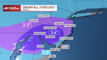
Keep in mind with this storm that just because you are in an area where up to 6 inches of snow could fall doesn't mean you will get half a foot. Those higher totals are expected in pockets, not widespread.
Whatever snow does fall, people should be quick to clear it off driveways, sidewalks and cars as more bitter cold grips the region on Saturday.
Why might some neighborhoods get more snow than others?
The interesting storm set-up that could bring a band of locally, heavier snow is called a Norlun Trough. This is an inverted trough where the heavier snow would set up on the northwest side of the low-pressure system. This is the area where we’re anticipating the highest snow totals to occur, which at this time could be 4 to 6 inches, possibly locally higher.
The strongest snowfall is expected in the afternoon.
These kinds of events are very hard to forecast and pinpoint and the places that get around 6 inches of snow are expected to be in pockets.
The last time we saw this event in our area, was in December 2018, when the Atlantic City area got 4 to 8 inches of snow and parts of South Jersey got 2 to 4 inches. Just a little further down the Shore, Cape May remained dry.
States of emergency in Philly, NJ
Philadelphia is under its first snow emergency in a couple years. It started at 7 a.m.
The Philadelphia Office of Emergency Management explained what that means:
"A Snow Emergency means all parked vehicles must be moved off snow emergency routes for plowing. When moving your car, park as far from the corner of the street as possible; vehicles parked too close to the corner get in the way of snowplows trying to turn corners.
"Snow emergency routes, primary roads, and secondary roads will be serviced first to allow for safe passage. Residential streets will be treated after the primary and secondary roads are safe to travel. This does not mean roads will be completely clear of snow and ice but made passable for safe traveling.
"We strongly encourage people to stay home and off the roads as much as possible. The frigid temperatures and cold ground will make it easy for snow to accumulate and cause slippery travel on untreated roadways."
Mayor Cherelle Parker urged people to "take this moment to slow down, exercise caution if you are traveling, and take care of our neighbors."
Many residents in Philadelphia and surrounding communities are still recovering from the storm earlier this week. As NBC10's Miguel Martinez-Valle reports, many are stocking up on more ice melt and shovels in Roxborough.
New Jersey Gov. Phil Murphy has kept a state of emergency in effect ahead of the storm. The action allows "resources to be deployed throughout the state during the duration of the storm," Murphy's office notes.
As Leah Uko reports, officials in South Jersey were ready for the storm.
Chester County courts and offices were closed Friday. Be sure to check if where you are going is open before you head out.
Is school open? Get list of school closings, delays
Will school be closed on Friday?
Before the end of the school day on Thursday, the Archdiocese of Philadelphia announced that all Archdiocesan high schools and parochial elementary schools would be closed Friday.
All schools in the Philadelphia School District will be closed for a snow day, according to Superintendent Dr. Tony Watlington.
NBC10's Deanna Durante spoke with the superintendent for the Norristown School District to find out why officials there decided to make Friday a virtual learning day rather than a day off for the storm.
In total, hundreds of schools made the decision to close Friday.
That should allow plenty of kids the chance to sled and have fun in the snow. NBC10's Randy Gyllenhaal even got on his sled to test it out.
Click here for our First Alert Weather School Closings page.
How do you walk on icy sidewalks?
Any leftover snow on the ground is not expected to melt. So, watch out for slippery spots and walk like a penguin to avoid falling. This video explains how to stay safe.
What if I need to drive somewhere?
Officials are urging people not to travel unless they need to.
Ahead of the storm, the Pennsylvania Department of Transportation (PennDOT) and Pennsylvania Turnpike Commission (PTC) advised "motorists to avoid unnecessary travel during the storm."
A commercial vehicle travel restriction has been issued for many interstate highways in New Jersey, according to the New Jersey Department of Transportation. The restriction went into effect starting at 3 a.m. Friday.
With temps plummeting heading into Saturday, roads are expected to be very icy overnight.
For those who must hit the road, AAA Mid-Atlantic suggests you remove all snow from your car before you go, pay attention to any adjusted speed limits, don't tailgate and stay calm should your car skid.
For drivers making their way into Center City, the Philadelphia Parking Authority is offering a flat $5 rate for 24 hours at six garages.
When does the next Arctic blast begin? 🥶
Make sure you have ice melt ready to throw down once you clear the snow Friday.
Temps plunge heading into the weekend. Lows on Saturday and Sunday will be in the teens.
The feels-like temps on Saturday morning are expected to be in the single digits and the highs Saturday aren't expected to get out of the mid 20s.
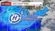
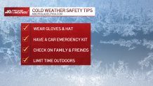
Exposure to temps that frigid is dangerous to your health and you should limit your time outside. Here are some tips to keep you safe and warm if you need to head out in the bitter cold.
Relief from the frigid conditions is on the horizon. Temps trend upward on Monday with the high above freezing ahead of rain to end next workweek.
Keep track of all the school closings, wintry weather and anything else Mother Nature brings our way by downloading the latest version of the NBC10 app.
Sign up for our Breaking newsletter to get the most urgent news stories in your inbox.
