
Roosevelt Boulevard, one of the most dangerous roads in America, could look completely different over the coming decades under the City of Philadelphia’s plan to transform it.
The plan, released Friday, includes short-term and long-term proposals to improve safety for both drivers and pedestrians. Some measures have already been rolled out in the last few years, but there are also other changes that could be in place by 2025, as well as two multi-billion-dollar suggestions to radically transform the 12-lane boulevard by 2040.
The proposed changes form the Roosevelt Boulevard Route for Change Program, a collective effort by the City of Philadelphia, the Pennsylvania Department of Transportation and SEPTA first launched in 2016 using federal grant dollars.
Their report underscores what most Philadelphians already know: Roosevelt Boulevard is a messy, confusing piece of road, tailor-made for crashes.
Get Philly local news, weather forecasts, sports and entertainment stories to your inbox. Sign up for NBC Philadelphia newsletters.
From 2013 to 2017, there were 2,846 crashes along the boulevard – nearly 46 crashes per mile, per year – according to the report. In those crashes, 81 people were seriously injured and 62 were killed, with 14% of all of Philadelphia’s fatal crashes happening on the boulevard during that period.
“The analysis shows that crashes are not confined to just a few intersections or hotspots. Rather, crashes across all modes occur consistently, block after block, intersection after intersection, for the length of the corridor,” the report concluded.
It also found that the people most impacted are lower-income and minority residents, with a greater level of poverty within the one-mile area around the road. The lower portion of the boulevard was found to have the "highest concentrations of lower-income, youth, and minority residents, as well as lower rates of car ownership."
There are several big problems, the report found, with some highlighted below:
- Limited sidewalk buffers: People walk along a sidewalk with a limited buffer between a high volume of drivers traveling at higher speeds.
- Minimal pedestrian refuge areas: Certain segments of the boulevard only provide minimal refuge islands for pedestrians, putting them at risk. Existing refuge islands at many locations along the boulevard are narrow and expose people walking to higher-speed drivers.
- Long distances between intersections with signals: There is a significant number of intersections that are spaced over 1,000 feet apart.
- Numerous driveways and access points: Driveways and other access points bisect sidewalks, creating more conflict points between people driving and people walking.
- Long crossing distances: At many intersections, people walking often don’t have a comfortable amount of time to cross and must wait on narrow medians between lanes of moving traffic until the next signal cycle, with each cycle lasting only 90 seconds in many areas. At some intersections, people waiting on multiple crossing cycles could spend up to six minutes just trying to get across the street.
- Sidewalk gaps: Significant sidewalk gaps north of Welsh Road, restricting pedestrian access to key destinations.
Goals by 2025
The report lays out several goals by 2025, including:
- Changing traffic signal cycle times: The program recommends increasing the 90-second signal cycle to 120 seconds in order to provide more time for people to cross and to reduce the chance of people getting caught in the middle of travel lanes while crossing.
- Realigning crosswalks and curb ramps: Many of the boulevard’s side streets are skewed, resulting in a longer crossing distance for pedestrians, and longer exposure to vehicles when crossing. Instead of people being forced to cross the street diagonally, crossing sections would be realigned to make them go straight across. In addition, curb ramps in disrepair would be fixed, allowing safer access to the elderly and people with disabilities.
- Closing sidewalk gaps: This would reduce the chance that people cross the street at locations without signals.
- Building curb extensions: Ten locations would see their curbs extended in order to reduce the distance that people have to walk to get across traffic.
- Improving bus stops: There are 142 SEPTA bus stops along Roosevelt Boulevard in Philadelphia, but only 22 stops (16%) have bus shelters. The plan calls for building more bus shelters, as well as adding more benches, lighting and bicycle parking. The plan also recommends eliminating some bus stops with only a few daily riders in order to speed up travel times for commuters.
- Adding bus-only lanes: Installing Business Access and Transit (BAT) lanes in the outermost lanes in each direction of the boulevard is another strategy to improve transit services. Called BAT lanes, they provide space for buses to travel separately from general through traffic, only encountering vehicles in the lane that want to make right turns either at a driveway or side street. Installation of BAT lanes is expected to reduce bus travel time along the boulevard, contributing significantly to the improvement of accessibility and reliability for transit riders.
- Adding landscaping and art: Large canopy trees play a critical role in scaling the boulevard and defining sections. The trees also help visually narrow the road, which could help slow vehicles. Smaller, but still civic scaled public art could be incorporated in wider medians.
Goals by 2040:
Local
Breaking news and the stories that matter to your neighborhood.
A little under two decades from now, Roosevelt Boulevard could be completely transformed. There are two plans that would accomplish this: One would be a $1.9 billion “neighborhood boulevard,” while the other would be a much more radical, $10.8 billion “partially capped expressway.”
Neighborhood boulevard:
This would make Roosevelt Boulevard look more akin to the Benjamin Franklin Parkway, reducing the boulevard to 10 lanes. It would have five key components:
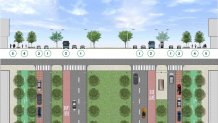
- Six at-grade general-purpose lanes – three northbound and three southbound.
- In each direction, two inner (express) lanes will be separated from the outer (local) by the BRT bus lane and side median.
- Local buses will travel and stop in the outermost general-purpose lane during off-peak hours.
- The posted speed limit will decrease to 25 mph for these six at-grade lanes.
2. Two flex lanes – one northbound and one southbound in the outermost position.
- During non-peak hours, the flex lanes are used to pick up bus riders at local bus stops, for on-street parking, and for loading/delivery.
- During peak hours, the flex lanes are converted to Business Access and Transit (BAT) lanes.
3. Two dedicated BRT lanes – one northbound and one southbound. In each direction, the BRT lanes will be located between the side median and the pair of travel lanes.
4. Two two-way cycle tracks – one adjacent to northbound boulevard and one adjacent to southbound Boulevard, buffered from traffic by landscaping and at the same height as the sidewalk.
5. Widened sidewalks along both sides of the boulevard.
Partially capped expressway:
This is the much more expensive option and would include sending four lanes underground and building a large median above them. At ground level, there would be six lanes, with two becoming bus-only lanes. It also has five key components:
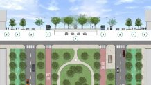
1. Four below-ground expressway lanes – two northbound and two southbound. The posted speed limit will increase to 50 mph for these expressway lanes.
2. Four ground-level local (outer) lanes – two northbound and two southbound. The posted speed limit will decrease to 25 mph for these outer (local) lanes.
- Local buses will travel and stop in the outermost lane.
- New entrance and exit ramps will connect the below-ground expressway lanes with the ground-level local lanes at nine key locations.
3. Two dedicated BRT lanes – one northbound and one southbound. BRT lanes will be located between the side and center medians of the boulevard.
4. Two two-way cycle tracks – one adjacent to northbound boulevard and one adjacent to southbound boulevard, buffered from traffic by landscaping and at the same height as the sidewalk.
5. Widened sidewalks along both sides of the Boulevard.
On Friday, Mayor Jim Kenney said the city is ready to partner with the administration of President Joe Biden on infrastructure projects, but he acknowledged that a reimagined Roosevelt Boulevard will take the collaborative efforts of various parties.
“In any case, we must continue to work together with state and city government officials, members of the community and advocacy groups to ensure a future boulevard that is safe, accessible and reliable for everyone," he said. "I’m convinced as committed partners, we can accomplish a great deal, and so I invite you to join me as we make this journey on the route for change for Roosevelt Boulevard."
