
What to Know
- Widespread flooding was reported Wednesday morning after another storm hit the Philadelphia region. Damaging winds also led to power outages.
- A First Alert for flooding and damaging wind is in effect for the entire region into Wednesday.
- Be sure to keep checking back with NBC10 News on air, online and in our app for the latest storm impacts.
The rainstorm that raged through the Philadelphia region brought with it historic flooding in at least one location, widespread power outages and hazardous travel conditions. Dozens of schools were closed or delayed Wednesday morning and roads throughout the region were closed due to high water.
The NBC10 First Alert Weather Team issued a First Alert for Tuesday afternoon into Wednesday for flooding rain -- more than 4 inches fell in parts of Pennsylvania -- and damaging wind that would lead to power outages. The flood threat and strong winds continue even after the rain stopped early Wednesday.
Rain began falling late Tuesday morning. The intensity increased during the afternoon and continued to increase in the evening as winds picked up. The worst of it hit before midnight. Despite overnight temps in the 50s, or even 60, the damage was done. Winds gusted during the storm and after, knocking down trees and taking out power with more than 100,000 customers in the dark before daybreak Wednesday.
Get Philly local news, weather forecasts, sports and entertainment stories to your inbox. Sign up for NBC Philadelphia newsletters.

Several delays and cancellations took place at Philadelphia International Airport and SEPTA and Amtrak also had service impacts. Driving was difficult with several roads blocked early Wednesday.
Flooding continues into Wednesday morning after inches of rain fell
The storm started with light rain falling late Tuesday morning and afternoon. That quickly changed as the afternoon went on, as winds picked up and downpours began.
Flooding also took place in parts of Brooklawn, New Jersey, late Tuesday afternoon.
Coastal flood warnings remained in effect along the Delaware River and several other area waterways. Some of those rivers crested several feet above flood level. (Click here for a full list of warnings and watches)
The most prone places to flooding were small creeks, streams and low-lying areas. Our bigger rivers -- including the Delaware and Schuylkill Rivers in Philadelphia -- rose overnight into Wednesday, leaving closures for the Wednesday morning commute. Luckily, the Delaware River receded enough along Columbus Boulevard near Spring Garden Street to reopen.
The road was closed again at noon however from Callowhill to Dock streets.
These roads in Philadelphia remained closed through the morning, according to Philadelphia police:
- Kelly Drive from Falls Bridge to Hunting Park.
- The entire length of MLK Drive where two trees were uprooted and "leaning against the Strawberry Mansion Bridge."
- Lincoln Drive between Gypsy and Wissahickon due to a muddy mess left on the road.

The Schuylkill Expressway and other major roads were moving early Wednesday, but some debris was possibly on the roads. NBC10's Keith Jones found that out the hard way after getting a flat on I-76, while heading into work.
In Delaware County, parts of Darby Borough were closed early Wednesday after the Darby Creek flooded onto MacDade Boulevard and other streets. At one point, the water was knee-high.
In Delran, New Jersey, the Delaware River crested at a record level, leaving flooded homes. One homeowner showed NBC10's Karen Hua how high the water got.
That high water came as Burlington County Public Information Office said the National Weather Service said "the Delaware River reached major flood stage in Burlington early this morning, cresting at a record-breaking 11.99 feet."
That nearly 12-foot crest broke the previous record of 11.9 feet measured on Sept. 1, 2021, the county said.
Schools opening late or closed
Some schools canceled after-school activities Tuesday as the storm intensified. Dozens more opened late (Abington Township School District) or closed (Tredyffrin-Easttown School District) Wednesday due to the storm damage.
(Check our School Closings page for the growing list of closures and delays.)
All Central Bucks School District schools are operating on a two-hour delay Wednesday as a result of the weather, the school district said in a text that was sent out. They also said kindergarten will operate on a "modified kindergarten" schedule.
Due to widespread power outages and flooding, schools and offices in the Colonial School District in Delaware was closed Wednesday. Another district in Delaware that was closed on Wednesday was Red Clay School District.
Tracking power outages after strong winds gust
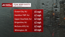
Wind gusts of 40 mph, 50 mph and even up to 65 mph brought down trees and impacted power lines.
The most damaging wind occurred at the Jersey Shore, where a 65 mph wind gust was reported in Ocean City. The strong winds spread into Pennsylvania where a 51 mph gust was reported at Philadelphia International Airport and Delaware where Wilmington had a 60 mph gust.
Power was slowly restored Wednesday, however, outages lasted into the afternoon.
Here are the power outage numbers across the region as of 2:10 p.m. Wednesday:
PECO
Bucks County - 1,615
Chester County - 22,789
Delaware County - 9,235
Montgomery County - 2,164
Philadelphia - 1,681
PPL
Bucks County - 1,001
Less than 1,000 each in Berks, Chester, Lehigh, Montgomery and Northampton counties
PSE&G
Burlington County - 2,166
Camden County - under 1,000
Gloucester County - 1,362
AC Electric
Fewer than 1,000 each in Burlington, Camden, Cape May and Ocean counties
Atlantic County - 1,934
Cumberland County - 4,053
Gloucester County - 5,352
Salem County - 2,534
Delmarva
New Castle County- 6,042
Be sure to power up your devices now in case power goes out where you are. You can always watch NBC10 News and get the latest updates on NBC10.com and in our app.
How much rain fell?
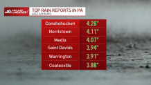
Some areas got more than 4 inches of rain from the storm, with many places getting around 2 inches, or more, of rainfall.
In Pennsylvania, Conshohocken topped the list of rainfall totals at 4.28 inches. More than 4 inches also fell in Norristown and Media.
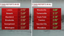
The hardest hit spots for rain in New Jersey were Woodsville (3.84 inches), Turnersville (3.17 inches) and Coyle Field (3.14 inches). Over in Delaware, Lewes got just under 3 inches of rain.
Flooding impacts SEPTA, Amtrak service
SEPTA shortened its Tuesday service on the busy Paoli/Malvern Regional Rail Line.
The "Paoli/Thorndale Line service will operate between Malvern and Center City only," SEPTA said. "Amtrak has advised SEPTA that flooding could cause service outages west of Malvern later in the day, and SEPTA is taking this proactive measure to ensure customers are able to return to their stations of origin in the afternoon and evening."
The issues on the Paoli/Thorndale Line continued Wednesday morning: "Service is suspended until at least 1 p.m. due to downed trees and other weather-related problems."
Just before 1, SEPTA announced that trains were once again servicing Malvern, though they weren't yet going to Thorndale. By 2 p.m., service was fully restored.
If you need to catch a bus or train, be sure to check social media and SEPTA's website before you go.
There were some Amtrak train cancellations due to the inclement weather and the Keystone Service between Philadelphia and Harrisonburg was at one point suspended.
Got a flight at PHL? Be sure to check your flight status before you go as some cancellations and delays are reported.
Tips to stay safe during and after a storm
Utilize these tips to stay safe:
During a storm, if you notice water rising or plan to evacuate:
- Unplug all electrical appliances.
- Shut off natural gas supply valve to any gas appliances. The valve is usually found on the gas line to the appliance.
What to do if your home or business is flooding?
- Don't touch any appliance in standing water.
- If you can do so safely, turn off any air conditioning or major appliances that may have been running when outage occurred. This will help avoid a power surge.
- Call local electric company or 911 if you smell gas.
- Don't go into basements with standing water, raw sewage or obvious electric hazards. Stay away from breaker box.
- Watch out for animals or snakes that may have been flooded out of their homes and are seeking shelter.
Philly emergency officials have advice for anyone dealing with storm damage or flooding to their property -- take photos, keep receipts, etc. They also want people to take a storm survey.
Be prepared for whatever Mother Nature brings
Be sure to watch NBC10 News and download the NBC10 app to get the latest forecasts, live radar and any weather alerts to help you stay safe during the storm. Having the app can also keep you updated if you lose power.
Sign up for our Breaking newsletter to get the most urgent news stories in your inbox.
