
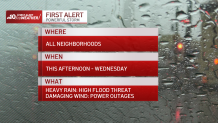
What to Know
- Flooding becomes a big concern Tuesday and Wednesday as another storm hits the Philadelphia region. Damaging winds could also lead to power outages - especially in South Jersey and along the Delaware coast.
- A First Alert for flooding rain and damaging wind is in effect for the entire region.
- Be sure to keep checking back with NBC10 News on air, online and in our app for the latest storm impacts.
Editor's Note (Jan. 9, 2024, 1:41 p.m.): This story is no longer being updated. For the latest as the storm hits, click here.
As neighborhoods have just dried out from weekend rain or dug out from snow, the next weather threat is nearing the Philadelphia region, bringing heavy flooding and power outage threats.
Get Philly local news, weather forecasts, sports and entertainment stories to your inbox. Sign up for NBC Philadelphia newsletters.
The NBC10 First Alert Weather Team has issued a First Alert for Tuesday afternoon into Wednesday for flooding rain and damaging wind that could lead to power outages.
Monday was dry, but Tuesday into Wednesday, strong winds and heavy rains are expected to impact the Philadelphia region. The rain is expected to start late in the morning.
Local
Breaking news and the stories that matter to your neighborhood.


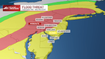
After the weekend storm left more than 5 inches of snow (or more) in parts of the Lehigh Valley and nearly a foot in the Poconos, rain and mild temperatures are going to lead to quick melting of the snow pack. That has led to a large swath of the region -- especially in the Pennsylvania suburbs, Lehigh Valley and Poconos -- being under a moderate risk for flooding.
Rain could fall at a rate of a half-an-inch an hour in some of the heavier storm pockets.
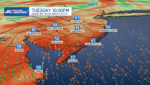
Add in the strong winds -- expected to gust above 60 mph along the Jersey Shore -- and power outages likely will happen from power lines and tree limbs coming down.
What to expect from flooding rains, damaging winds
On Tuesday, increased moisture and clouds moved into the region with temps expected to push well into the 50s. That sets up this storm to bring us not snow, but inches of heavy rain that could lead to widespread flooding and flash flooding.
Light rain started late in the morning and intensifies during the afternoon and evening. The storm is expected to span across the entire region and continue into early Wednesday.
A flood watch is in effect in Philly and the suburbs with a high wind warning through coastal Delaware and the Jersey Shore. Coastal flood warnings are in effect along the Delaware River and several other area waterways. (Click here for a full list of warnings and watches)
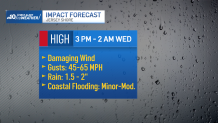
Most areas will see 2 to 3 inches of rain with the possibility of damaging winds of up to 45 to 65 mph. Some regions could get as much as 4 inches of rain from the storm.
Some schools even decided to cancel after-school activities due to the storm.
Jersey Shore storm threats include coastal flooding damaging wind
The winds are expected to be the worst along the coast, especially at shore points. Add in up to 2 inches of rain and there is a risk for minor to moderate coastal flooding.
Meteorologist Marvin Gomez said he is worried about flash flooding, urban flooding, flooding of creeks, rivers and streams.
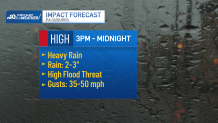
Threats in Pennsylvania suburbs including flooding
There is not only a chance for flooding due to the excessive rain in the Pennsylvania suburbs, but also a chance for flash flooding amid the heaviest pockets of rain late Tuesday afternoon into the evening. Winds could gust up to 50 mph, adding to the threat of power outages.
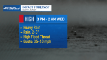
Strong winds and heavy rain expected in South Jersey
In South Jersey, heavy downpours could leave 2 to 3 inches of rain. Winds will gust from 35 to 60 mph.
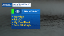
Strom brings heavy rain, high flood threat to Philly
Rivers and streams in Philadelphia could flood from this storm as 2 to 3 inches of rain are expected. Winds gusting up to 30 to 50 mph could bring down power lines.
Travel at Philadelphia International Airport is being impacted by the weather.
"This is a storm that will be a wind maker with gusts that would make travel difficult for high profile vehicles," Gomez said. "I am expecting delays and cancelations at PHL from this system."
As of midday, PHL was reporting at least 42 delays and and nine canceled flights.
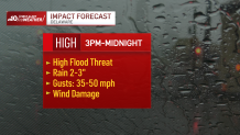
High flood, wind damage threats in Delaware
Folks in the First State should be prepared from wind damage from 35 to 50 mph gusts and a high flood threat from 2 to 3 inches of rain.
The rain is expected to quickly taper off after midnight. And, you could even see the sun by late Wednesday afternoon, but don't let that trick you as the flood threat for rising waterways lasts through Wednesday.
Gusty winds also continue Wednesday -- with gusts up to 30 to 40 mph. With the ground being saturated, more damage from trees or limbs falling could happen even after the rain stops.
State of Emergency for NJ
"This is one that I would strongly, strongly, strongly encourage folks to not underestimate."
On Monday, Gov. Phil Murphy declared a State of Emergency for New Jersey ahead of Tuesday's storm. The executive order allows all 21 counties in New Jersey to receive resources during the storm.
“Beginning tomorrow morning and continuing through Wednesday morning, we are expecting one to 4 inches of heavy rain, strong winds, and potential inland and coastal flooding,” Murphy said. “This storm will exacerbate the effects of the inclement conditions we experienced in December and this past weekend and may precede another storm Friday night. As always, I urge all New Jerseyans – including residents in our coastal and riverine communities – to follow all safety protocols and remain off the roads unless absolutely necessary.”
SEPTA changes service due to flooding fears
SEPTA has shortened its Tuesday service on the busy Paoli/Malvern Regional Rail Line.
The "Paoli/Thorndale Line service will operate between Malvern and Center City only," SEPTA said. "Amtrak has advised SEPTA that flooding could cause service outages west of Malvern later in the day, and SEPTA is taking this proactive measure to ensure customers are able to return to their stations of origin in the afternoon and evening."
SEPTA is also limiting parking at the Malvern Station. Drivers are urged to park at the Paoli Station.
Tips to stay safe before, during and after a storm
Plan ahead before bad weather hits. Here are some tips for what to do in preparation of a storm and during one.
- Downed wires should always be considered "live." Stay at least 30 feet away from downed power lines. Immediately report to local electric company.
- Avoid driving through large pools of water. Downed lines can be hidden beneath water and be live. If you encounter standing water while driving or on foot, stop, back up and choose another path.
- To prevent carbon monoxide poisoning, do not run gasoline powered generators in a garage or enclosed space.
- If you are on life-sustaining medical equipment, alert your local electric company and notify the police and fire department.
During a storm, if you notice water rising or plan to evacuate:
- Unplug all electrical appliances.
- Shut off natural gas supply valve to any gas appliances. The valve is usually found on the gas line to the appliance.
What to do if your home or business is flooding?
- Don't touch any appliance in standing water.
- If you can do so safely, turn off any air conditioning or major appliances that may have been running when outage occurred. This will help avoid a power surge.
- Call local electric company or 9-1-1 if you smell gas.
- Don't go into basements with standing water, raw sewage or obvious electric hazards. Stay away from breaker box.
- Watch out for animals or snakes that may have been flooded out of their homes and are seeking shelter.
Be prepared for whatever Mother Nature brings
Be sure to watch NBC10 News and download the NBC10 app to get the latest forecasts, live radar and any weather alerts to help you keep ahead of the storm. Having the app can also keep you updated should you lose power.
Sign up for our Breaking newsletter to get the most urgent news stories in your inbox.
