
What to Know
- The remnants of Ida, now a tropical depression after coming ashore in Louisiana as a Category 4 hurricane over the weekend, is expected to bring flooding rain and a tornado threat to the Philadelphia region.
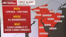
- The NBC10 First Alert Weather Team has issued a First Alert for flash flooding, severe storms and a possible tornado for 12 p.m. Wednesday until 12 p.m. Thursday for all Philadelphia area neighborhoods.
- Flash flooding is the biggest concern as inches of rain could fall in some neighborhoods. Severe storms, including an isolated tornado, can't be ruled out.
Editor's Note: This story is no longer being updated. For the latest on the impacts of the remnants of Ida on the Philadelphia region, click here.
After leaving a path of destruction across Louisiana and Mississippi when it came on land as a Category 4 hurricane Sunday, the remnants of Ida are taking aim at the northeast, bringing a flooding and tornado threat to the Philadelphia region on Wednesday.
The NBC10 First Alert Weather Team has issued a First Alert for flash flooding, severe storms and a possible tornado for 12 p.m. Wednesday until 12 p.m. Thursday for all Philadelphia area neighborhoods.
Get top local stories in Philly delivered to you every morning. Sign up for NBC Philadelphia's News Headlines newsletter.
Governor Tom Wolf signed a proclamation of disaster emergency Tuesday night in anticipation of the storm.
“This dangerous storm continues to have devastating impacts across the South and as it heads toward Pennsylvania, we are expecting significant rainfall across the state. This proclamation will allow for our emergency preparedness teams to provide any support needed throughout the storm and its aftermath,” Gov. Wolf said. “I urge Pennsylvanians to monitor local weather and traffic conditions before making any plans and prepare for potential flooding.”
Here is what is expected from Ida in our region.
Tracking the Remnants of Ida
Weather Stories


Tropical Depression Ida is continuing to weaken, but the remnants of Ida will bring plenty of moisture to the area by Wednesday and Thursday.
Some storms may begin overnight and bands of heavier rain will likely develop over our northern neighborhoods by Wednesday morning. However, the heaviest widespread rain is expected after 2 p.m. Wednesday and it should continue through the night and early Thursday morning. This is the time period that also carries the best chance of severe storms.
Rain amounts of up to 6-plus inches are possible. The highest totals will depend on the track of Ida, and could shift south into portions of South Jersey and Delaware. As a result, everyone in the region should be prepared for the possibility of street flooding as well as river and creek flooding.
Here are the estimated rain totals:
- The I-95 corridor and northward, including Wilmington and Mercer County, should get 3 to 5 inches of rain.
- Within that area, some spots may get 6 inches of rain or more.
- Areas southward are looking at 1 to 3 inches, with the lowest amounts likely near the Jersey Shore and southern Delaware.
As with most tropical systems, the threat for severe storms exists. Specifically, isolated tornadoes can’t be ruled out for the region Wednesday. The flash flooding threat is greatest north of the I-95 corridor with the severe storm threat the greatest in South Jersey, Delaware and shore points.
The area is under a Flash Flood Watch from 8 a.m. Wednesday until 8 p.m. Thursday.
It won't take much rain for flooding to begin because the ground has been saturated by recent storms including the remnants of Fred and Henri. Recent localized downpours caused flooding in portions of Montgomery, Bucks and Philadelphia counties as well as parts of Atlantic and Cape May counties this past weekend—an indication that much of the region is vulnerable to flooding.
Just 1 inch of rain in a three-hour period could bring flooding to some towns within the Pennsylvania suburbs, Lehigh Valley, Berks County and Philadelphia.
Areas prone to flooding should begin preparations now like clearing gutters and storm drains, moving important items out of basements and charging power banks and devices.
The WPC (Weather Prediction Center under NWS) 1-day/24-hour rainfall forecast for southern Pennsylvania on Wednesday is on par with that of a 100-year flood. That means that a flood event of this magnitude only has a 1% chance of happening any given year. The last 100-year flood in our region took place in July.
High Tornado Risk
On Wednesday the region will be in the 10 percent tornado risk area which is significantly high.
Most of South Jersey and Delaware have the best chance of seeing an isolated tornado on Wednesday.
According to the National Weather Service, the last two 10 percent tornado threats in our region occurred on September 3, 2020, and August 4, 2020, during Isaias in which there were five confirmed tornadoes.
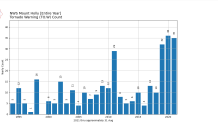
So far this year, the National Weather Service Mount Holly has issued 35 tornado warnings in our region, one shy of the record set last year.
What You Can Do to Prepare for the Storm
On Tuesday, you can be getting ready for whatever Ida brings.
The key is to make sure water has a clear path to clear away from your home and neighborhood and to make sure your phone is charged.
- Clean out your gutters of any debris.
- Clear street drains and other drains near you home. Leaves, trash and other debris can cause a blockage.
- Check your basement, make sure sump pump is working and move out any important items you don't want to get wet.
- Download the NBC10 app and make sure you charge your device as you could lose power during the storm. If you have any backup power banks, make sure those are also charged up.
It is especially important to have your phone charged and app notifications on should a severe weather alert come out in the middle of the night.
Also, you may want to reconsider travel on Wednesday afternoon and night due to flooding and poor visibility from the storms.