
What to Know
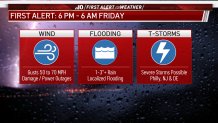
- A storm system that could pack rare Christmas thunderstorms is expected to put a damper on the holiday in the Philadelphia region. A First Alert is in effect until 6 a.m. Friday.
- Temps pushed into the 60s before the main event of rain arrives Thursday afternoon into evening. Temps will be in the 30s by the end of Friday.
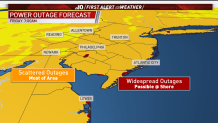
- Wind gusts (up to 60 mph in some areas) are a big concern as they could knock out power and blow around any untethered Christmas décor. The best chance for widespread power outages is along the Jersey Shore and Delaware Beaches.
Tens of thousands of people were without power Christmas morning, as a gut-punch of a storm packing strong winds and heavy rain walloped the region.
The outages were scattered throughout Pennsylvania, New Jersey and Delaware.
CLICK HERE for updated power outage information and storm damage reports as this story is no longer being updated.
Get top local stories in Philly delivered to you every morning. Sign up for NBC Philadelphia's News Headlines newsletter.
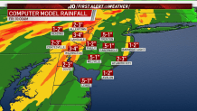
We could see an inch or two of rain in many parts of our region. Santa may track in some mud!
Winds are expected to keep whipping into the wee hours of Christmas morning. Christmas decorations could blow away if not tied down.
Ahead of the Grinchy storm, the First Alert Weather Team issued a First Alert from 6 p.m. Thursday to 6 a.m. Friday, as the most impactful parts of the storm strike the area.
Who Will Be Impacted?
The storm has powered across the United States, pushing warm air up along the leading edge of the storm. That warm air already arrived Thursday (Christmas Eve) morning with temps already in the 50s. The highs should top out in the 60s in many neighborhoods — well above average for December.
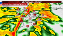
Neighborhoods to the north and west of Philadelphia, including the Lehigh Valley, Berks County and parts of the Pennsylvania suburbs began to see some rain midday Thursday. Showers should begin in Philadelphia, South Jersey and Delaware in the afternoon.
Then, late afternoon into the evening, heavy rain will begin spreading across the Philadelphia region. The rain intensified in the early evening. Through the night, this rain will continue to drench the Delaware Valley with thunderstorms likely. Temps after midnight are expected to be in the 60s.
A Christmas storm like this is rare. Thunderstorms on Christmas in the Philadelphia region last happened in 1978.
The best bet is to stay home overnight to ride out the wild weather.
Winds Could Blow Around Christmas Decorations, Rain Could Lead to Flooding
While all neighborhoods could see thunderstorms, Delaware, South Jersey and the Jersey Shore have the best chance at seeing damaging winds.
Howling wind gusts will begin to strengthen by Thursday afternoon and evening. Expect wind gusts to hit 50-plus mph in most inland areas, with stronger winds on the coast. In either area, winds could topple holiday décor and could cause power problems.
After we saw a wind gust of 63 mph in Wilmington, we bumped up our maximum predicted wind gusts to 70 mph.
Be sure you charge your phone during the day so you are ready in case you lose power during the storm.
Jersey Shore and Delaware Beach communities have the greatest possibility of widespread power outages due to wind gusts nearing hurricane strength.
Earlier Thursday, a PSE&G spokesman told us the company understands its customers will be extra eager to get their power back on as many celebrate Christmas with their families.
"We appreciate that this is not a good time of the year to be without power," Tony Garrihy said. "Our folks will be on duty, ready to address this situation."
Utility crews are coming in from four states and prepared to work through the holiday and into the weekend if necessary.
The most likely time for damaging winds is from 9 p.m. to 4 a.m., as many people are asleep.
The winds are expected to be worst in Delaware and New Jersey neighborhoods south and east of Philadelphia. The threat for flooding brought on by snow melt is expected to be the greatest north and west of the city.
Rain will continue to fall into Christmas morning, but should exit between 9 a.m. to noon. Altogether, 1 to 2 inches of rain could fall, with upwards of 3 inches or more in some suburban neighborhoods. Areas with snow left on the ground Thursday -- most likely near the Lehigh Valley and Berks County -- will see rapid melting thanks to warm temperatures in addition to the heavy rain. This could trigger some localized flooding for northern neighborhoods.
Basically, neighborhoods expected to get the worst of the rain won't have the worst of the wind and the areas with the strongest wind gusts won't get as much rain.
When Will Cold Air Arrive?
Once the rain exits on early Christmas morning, cold air will filter into the region quickly. Temperatures Friday morning may start in the upper 40s but fall to the low to mid 30s by late afternoon. At one point you could have Philly in the 60s and outer suburbs already dropped into the 30s as the transition happens.
It will still be breezy on Christmas afternoon, and partly sunny conditions return.
The weekend will continue to see cold weather as sunshine returns and high temperatures only hit the 30s Saturday before warming into the low 40s Sunday.
Any Chance of a White Christmas?
Snow showers are looking highly unlikely on the back-edge of the system, since it’s likely to exit before the coldest air has settled. However, the Lehigh Valley and Berks County still have a very low chance of seeing a few flakes before the storm leaves the area.

Make sure you download the NBC10 app and keep checking the First Alert Weather forecast on air so you can get any updates on the Christmas forecast even if you lose power.