
What to Know
- Grab your umbrella and be weather aware on Wednesday, April 3, 2024.
- The Philadelphia region is getting hit with gusty showers and even possible thunderstorms that could pack flooding downpours, damaging winds, hail and even an isolated tornado threat. A tornado watch is in effect in Kent and Sussex counties in Delaware.
- The best chance for severe storms is in southern parts of Delaware and New Jersey.
The dreary and crummy start of April continues Wednesday with more rain and gusty winds, but now with chances of heavy downpours, flooding and even a slight chance for severe thunderstorms. People in Southern Delaware were placed under a tornado watch.
The likelihood to see severe weather on Wednesday depends on where you are. A slight chance for a severe thunderstorm or even an isolated tornado to form is more likely in central and southern Delaware than neighborhoods to the north, while the Lehigh Valley and Pennsylvania suburbs could potentially experience downpours that lead to flash flooding.
Get Philly local news, weather forecasts, sports and entertainment stories to your inbox. Sign up for NBC Philadelphia newsletters.
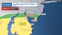
Here is a breakdown of the threats for severe weather Wednesday afternoon:
Tornado threat can't be ruled out
The main severe threats Wednesday are damaging wind and hail. However, there is a slight chance of a tornado spinning off storms in the afternoon. The area where these are most likely is in central and southern Delaware and into extreme South Jersey.
A Tornado Warning went into effect for Sussex County, Delaware, early Wednesday evening before expiring at 5:45 p.m.
Weather Stories

Earlier Wednesday afternoon, the National Weather Service had Kent and Sussex counties in Delaware under a tornado watch until 7 p.m. The watch means to be aware of the possibility for the severe weather threat.
Winds could gust throughout the region up to 40 mph.
Flooding concerns
A flood watch is in effect through much of Wednesday for Philadelphia, the surrounding Pennsylvania, Delaware and New Jersey suburbs, the Lehigh Valley and Berks County. Ponding on roadways a minor creek flooding are possible.
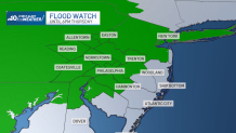
Flash flooding is a concern up into the Lehigh Valley due to storms packing heavy downpours that could hit in the afternoon.
The National Weather Service issued a flood warning from late morning into late afternoon for minor flooding along the Brandywine Creek in Chester County, including in Downingtown.
A coastal flood warning is also in effect until Thursday morning for parts of Ocean and Burlington counties.
When will all this rainy weather end?
Rain and storms are expected on and off through Wednesday evening.
Skies clear overnight into Thursday before another round of potential showers and storms move in during the afternoon.
Clouds remain Friday, but the rain is expected to be gone in time for the start of the weekend, which is expected to be clear.
Be sure to download the NBC10 app to your devices so you are ready for whatever Mother Nature brings.
Sign up for our Breaking newsletter to get the most urgent news stories in your inbox.
