
What to Know
- The entire Philadelphia area is under a First Alert Tuesday for drenching rain, potential flooding and strong winds from Isaias.
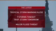
- Coastal and inland counties in New Jersey, Delaware and Pennsylvania are under tropical storm warnings as Isaias makes its way northward.
- The storm is packing heavy rain that will cause flash flooding. Three to 6 inches of rain are expected with isolated neighborhoods getting around 8 inches totals Wind Gusts up to 60 mph are possible in Philadelphia, 70 mph at the Jersey Shore.
Editor's Note (Aug. 4, 2020, 6:40 a.m.): This story is no longer being updated. Click here for the latest on Isaias and its impacts on our area.
Drenching rain will bring flooding to our region from the coasts to the Lehigh Valley and places in between Tuesday as Tropical Storm Isaias moves into the region. A tropical storm warning is in effect for most of the Philadelphia region.
Isaias was previously at hurricane strength Monday night as it made landfall in the Carolinas.
A FIRST ALERT is in effect for our area all day Tuesday due to the stormy impact of Isaias, which is expected to bring flash flooding, power outages and coastal flooding to our region. The First Alert kicked in at 7 p.m. Monday as drenching rain began.
Governor Phil Murphy declared a State of Emergency for New Jersey Monday night ahead of Isaias.
A tropical storm warning was already in effect Monday for area counties in Pennsylvania, New Jersey and Delaware, with the exception of Berks County and the Lehigh Valley. The risk of flash flooding, damaging wind and heavy downpours spreads to the entire region, including the northern and western suburbs.
Local
Breaking news and the stories that matter to your neighborhood.


"It is going to track right over our area," NBC10 First Alert Weather meteorologist Glenn "Hurricane" Schwartz said while noting it doesn't appear Isaias will move off to sea.
Rain could fall at 1 to 3 inches per hour during the heaviest rain bands expected late morning into the early afternoon. Widespread street, urban and stream flooding is expected from the heavy rain.
In addition, wind gusts up to 40 mph are possible in the Lehigh Valley, 60 mph in Philadelphia and 70 mph at the Shore. Widespread power outages are possible from these gusts.
Monday was quiet and hot during the day. Highs reached the upper 80s. Storms moved through some neighborhoods Monday night.
The Monday night storms brought a severe thunderstorm warning to South Jersey around 7 p.m.
The main impacts from Isaias will be felt Tuesday as the storm moves in from the south.
Despite some gusty winds, the biggest impact will be flash flooding with 3 to 6-plus inches of rain likely across the area, with locally higher amounts in heavier rain bands. Some places could get 8 inches or more of drenching rain.
This will cause widespread flooding concerns Tuesday. The most vulnerable spots for flooding are in and around Philadelphia, the suburbs, Berks County and the Lehigh Valley. In these areas it takes much less rain to trigger flash flooding due to soil type and also recent heavy rainfall. Places like Reading, Pennsylvania, were already hit with inches of rain over the weekend.
Power outages are a concern form the heavy rain and wind. So, be sure to power up your devices.
In addition to heavy rain and strong wind, the coast will also experience dangerous rip currents and coastal flooding. The severity of the coastal flooding is still uncertain, but at least minor coastal flooding at high tide is possible Tuesday and Tuesday evening. Once the storm track is more certain, we will have a better idea if coastal flooding becomes a bigger concern. A moderate risk for rip currents is in effect for the shore Monday with a dangerously high risk Tuesday.
As of Monday night, Isaias made landfall in North Carolina with strong winds and heavy rainfall.
Isaias is expected to move quickly past our area by Tuesday night and should be gone by Wednesday. Sunshine and pleasant weather return Wednesday and Thursday with highs in the 80s. A much needed break after the next few days.
Make sure you keep checking back with NBC10 News and download the NBC10 app for the latest on the storm as it moves up the coast.
Mon: Clouds build, very warm, and humid. Late day and night t-storms. Highs around 90.
Tue: Periods of heavy rain and t-storms. Tropical storm conditions likely in the afternoon and evening. Flash flooding likely second half of the day. High in the upper 70s.
Wed: Mostly sunny and less muggy. High in the mid 80s.
Thur: Mostly sunny and warm. High in the mid 80s.
Fri: Chance of showers. High in the 80s.
