“SO YOU’RE TELLING ME THERE’S A CHANCE”
No, it’s not like that famous quote from the ridiculously stupid yet funny movie: “Dumb and Dumber." Jim Carrey’s character is told he has a “one in a million” chance to get the girl. And that’s enough to thrill him that “there’s a chance." Well, a meteorologist needs a bit more confidence to predict snow in the 2nd half of March-less than a week after back-to-back record 80+ degree days.
SPRING SNOWS IN PHILADELPHIA
Spring officially begins Sunday, March 20th, and that’s the day with the best chance of seeing snow (maybe overnight into the 21st as well). You may be surprised not only how often it has snowed after that date, but how much has fallen. Even on that very date.
March 20, 1958 saw not only the biggest single snowfall I’ve ever seen in our area (up to 50”!), but the biggest snowfall contrast from the coast (a mere 2-3” at some shore areas) to areas N&W of Phila. (30”+). Here is the weather map and snowfall map for that storm:

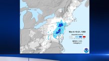
And this was the result in the area of the 50”, the Morgantown exit of the PA Turnpike, where helicopters had to rescue many who were stranded:

NOW THAT I HAVE YOUR ATTENTION
Local
Breaking news and the stories that matter to your neighborhood.
Of course, I am NOT predicting a repeat of that freakish storm. I am saying that not only can it snow in late March-it can stick if conditions are right. There’s a lot of moisture available in spring, so if it’s cold enough, snow can pile up quickly. Most times, though, it just melts as it falls, or shortly after it stops.
We have seen measurable snows as late as April 27th (1967), and even fairly big snows up to April 9th (7” in 1917). And, in April, 1915, we actually got 19.4” officially IN PHILADELPHIA!
So, what are our chances this spring?
“WHAT DOES THE EURO SHOW?”
That’s the main question I have trained many of my viewers and readers to ask whenever there’s a chance of a coastal storm 3-10 days out. As we’ve shown many times, the European is simply the best overall model in the world, has been for more than 20 years, and will continue to be the best indefinitely. It is not perfect and never will be, but:
1) It cannot be ignored – same as Glenn Close in “Fatal Attraction”
2) The ensembles of the EURO are even better than the EURO itself
So let’s start with the EURO:
Here are the forecast maps for Sunday 8am and Monday 8am…
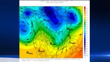
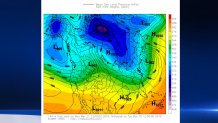
Unfortunately, the European folks are quite stingy with the maps they provide for free: only every 24 hours, so we’re missing the crucial Sunday evening map to see how far offshore the storm tracks. But the point is that there is a storm, and that it is basically cold enough to snow, and the storm tracks off the coast, keeping the cold air in place. These are minimum requirements for such a storm to bring snow in spring.
The ensemble members (the model is run 51 times with slight changes in initial conditions) strongly agree with this basic analysis.
ANY OTHERS IN AGREEMENT?
The ensembles of the Canadian Model (another one that beats the U.S. GFS model overall) are in the same area:
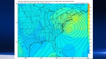
The tiny red numbers are centers of the LOW pressure at 2 a.m. Monday from the various ensemble members. That’s an impressive “grouping” just off the coast more than 5 days in advance. The average position is in a favorable place for at least a close call of snow around here.
THE BOTTOM LINE
I didn’t bother to mention the U.S. model, which was recently upgraded. It’s not that far off the solutions shown above, but this far out, it has a pretty bad track record.
The European Model has also just been upgraded, with much higher resolution, and the forecasting world is pretty excited about seeing how it works out. This may be the first test of a Nor’easter. It did very accurately predict the monstrous rain amounts in Louisiana and Texas that led to the recent record flooding.
We’re still many days away from any potential snow. And remember, snow at this time of year can melt quickly. So don’t go canceling any plans at this point. But this is not just a “whim," and it’s not “hyping” to put snow in the 7-day forecast for late Sunday and Sunday night for at least part of our area. More updates are coming this week. Stay tuned.


