
Hurricane Irma made landfall over Cuba Friday night.
It was the first time a Category 5 hurricane hit the country since 1924. While it was wreaking havoc over Cuba, Florida began experiencing Irma’s wrath.
Strong gusts and pockets of heavy rain within arm bands approached the southern tip of the state. Gusts were already between 50-60 mph around Miami Saturday morning.
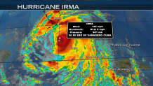
Here are Irma’s current conditions, as of the 2 p.m. update. While Irma’s winds weakened from Category 5 level down to Category 3 throughout Saturday morning, it’s still an "extremely dangerous" storm, packing maximum sustained winds of 125 mph, according to the National Hurricane Center. The state of Florida is only about 150 miles wide. The turn north was projected to begin Saturday afternoon, which will lead Irma to Florida.
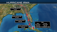
Forecasters adjusted the storm's potential track toward the west coast of Florida and away from the Miami metropolitan area of 6 million people. Despite this, forecasters still warn that Irma's hurricane-force winds were so wide they could reach coast to coast. Landfall over the Florida Keys as early as Sunday morning is expected. As Irma moves through the warm water of the Straight of Florida, it’s likely the storm will power back up to a Category 4 hurricane. Irma is projected to ride the coast throughout the rest of Sunday, approaching Tampa for a possible second landfall by Sunday night into early Monday morning. Notice the cone projection. It still includes much of Florida, or even areas slightly farther off shore into the Gulf of Mexico. This indicates the track still is not set-in-stone. Hurricanes fluctuate too much for a guarantee of specific landfall location. Regardless of the exact path, it is certain that Florida will experience devastating and life-threatening effects. Let’s talk about those threats below.
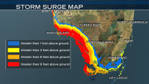
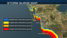
First, storm surge. What is storm surge? It’s the rising of the ocean waters due to a hurricanes powerful winds and extremely low pressure. The water piles up and is thrust forward onto land. The worst storm surge hits the areas where the winds are flowing onshore, and in the locations closest to the strongest gusts. In Southwest Florida, the storm tide may hit between 8-12 feet if peak surging occurs with high tide. For the Southeastern coast of Florida, 5-10 feet is possible.
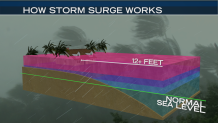
Take a look at what 12 feet of storm surge could look like: absolutely devastating. The purple area is 6 feet of surge, and the blue is 3 feet.
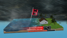
Now let’s talk winds. Category 4 hurricanes are defined by winds between 130 and 156 mph, sustained. Gusts can be even higher. At that speed, catastrophic damage is likely to occur. The strongest winds wrap around the eye of the storm, in something called the eyewall. The very strongest winds typically extend about 10-30 miles outside of the eye, but hurricane force winds (74+ milies per hour) are extending about 70 miles out from the center. Tropical storm force winds (39 mph – 73 mph) will envelope the entire state of Florida as Irma passes.
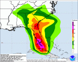
How about rain? Here’s a look at the latest rain total forecast by the NHC. The Keys may see 10-20” of rain, with locally higher amounts. The Florida peninsula is likely to receive between 8 and 15 inches, with isolated higher amounts. This will lead to flooding concerns, even for areas that are not impacted by storm surge.
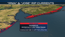
Irma, combined with Hurricane Jose (a category 4 storm projected to impact the Leeward Islands before spinning out to sea), are churning the waters. As a result, we’re seeing high risks for rip currents to form along all of our shores. From the Jersey Shore to the Delaware Beaches, it’s best to stay out of the water. We’ll have more updates on Irma’s movement as the storm aims to make landfall tomorrow morning.
