
THE CALENDAR REVERSAL
No, that’s not a typo. It’s not really March, of course, but it will be feeling like it for much of the next couple of weeks. And this is after setting another record for our warmest April ever recorded. It’s like going back in time!
April 2017 had an average high temperature of 69. That’s closer to “normal” May numbers than April. Now, we’re getting into a weather pattern where our highs will be closer to 60, which is our average high for late March. So, yes, we will see March-like weather, and not just for a day or two.
AN EXTREME PATTERN BRINGS EXTREME WEATHER
We don’t just get extended periods of below-normal temperatures anymore-at least not often. The Philadelphia average temperatures continue to go up each decade, the same as the world has been doing. It takes an extreme weather pattern to get long periods of cool temperatures. That’s exactly what is happening now.
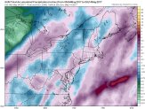
The key is seen at upper levels of the atmosphere (as usual). Meteorologists follow these changes at a level close to 20,000 feet above the ground (Why here? You don’t want to know). Here is the predicted map for this Saturday evening:
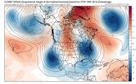
The BLUE areas have pressures well below normal; the RED areas are well above normal. The dark BLUE and dark RED represent the most extreme numbers we ever see (at least close to that-look at the scale on the right).
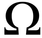
There are FOUR distinct areas of very LOW pressures, from the Atlantic to the Pacific. Notice how evenly spaced they are. Then notice the zones of red between them. This is called an “Omega Block”, since it looks so much like the Greek letter.
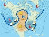
We see Omega Blocks often. But this time it’s a TRIPLE OMEGA! There are three of them in a row. That makes the pattern even more stable-more “blocky”. So, whatever type of weather you’re stuck in, it’s going to last for quite a while. Ask the unfortunate people in Missouri, Arkansas, and Illinois, who are seeing record flooding. Of course, if you’re in the “right part” of the omega, you can see nice weather for weeks.
Local
Breaking news and the stories that matter to your neighborhood.


Eventually, of course, the Omega shifts, and the weather changes. And now, it’ll be our turn to get stuck in it. We won’t be in the real rainy part, but it will be the cool, cloudy part. And that’s where the March-like weather comes in.
Fast forward a whole week. How much has the pattern changed? Not much.
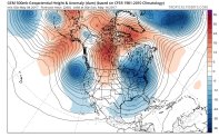
That is amazing! Being in the BLUE area means we will still be having much below normal temperatures, and lots of clouds. The wettest weather should be along or just off the coast.
So, once the cloudy and cool weather moves in this weekend, get used to it. It’ll be with us for quite a while. Here is one computer model’s look at how much rain will fall between tomorrow and next Saturday.
It’s more than 3 inches in much of our area, with most of it coming Friday and again next Friday. In between, we’ll see a lot of clouds and unseasonably cool air. As I said earlier-more like late March (especially Sunday and Monday). It may even be cold enough for some snow in the Poconos this weekend.
