EUROPEAN VS. USA- HERE WE GO AGAIN
By now, you’ve surely heard about the ongoing battle between the extended weather models, the GFS from the USA, and the EUROPEAN (from guess where?). There are many people who haven’t, but I doubt that they are reading this. As we’ve written before, there are technical reasons why the EURO is better overall.
The biggest EURO “victory” was their forecast for “Superstorm” Sandy in 2012. The EURO predicted the rare left turn at the same time the GFS predicted it going far out to sea. That’s when articles about the EURO superiority spread. Here’s one.
Scientific American had a good story on the model battle when the GFS suggested Hurricane Joaquin would hit the U.S., while the EURO suggested a miss.
Guess where Joaquin went? Yup, you’re right. Harmlessly out to sea.
Of course, the GFS wins sometimes. If it didn’t, why would we bother looking at it? I will say, though, that WAAAY too many U.S. forecasters put WAAAY too much faith in the GFS. I’ve seen this for the 20+ years that we’ve been able to see the EURO. The EURO doesn’t make it easy for us in the states. They charge huge amounts of money for access to all but the most basic of their products.
ANOTHER HUGE “BATTLE”
As a highly competitive person myself (just ask my wife about our ping-pong matches), I am drawn to competitions of all types. And, as a meteorologist for decades, comparing one computer model to another has been a daily challenge. We often see significant differences between the GFS and the EURO (and other models, too). But the current “battle” is astonishing.
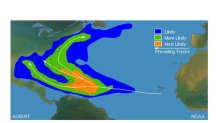
We are now getting into the historical peak part of hurricane season, and we look to the Tropical Atlantic for signs of storm formation. When the National Hurricane Center (NHC) sees a cluster of thunderstorms that might develop, it gives it a number. The system we’re focusing on now is called “Invest 99L”-the LOW on the right side of the image below (if it becomes a Tropical Storm, its name will be Gert). It just happens to be in a location where a lot of August storms tend to form:


It’s not exactly a surprise that the EURO predicts Invest 99L to track along one of the “most likely” zones in the above graphic. The GFS? Very different.
Local
Breaking news and the stories that matter to your neighborhood.
THE EUROPEAN-NOT FAR OFF THE U.S. EAST COAST
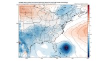
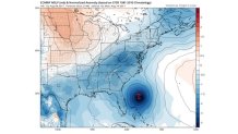
The Tuesday model run of the EURO is very similar to the previous two. In fact, all three are practically identical. That’s enough to raise your eyebrows. Here is the forecast for Sunday 8 a.m. and Monday 8 a.m.:


That’s a little too close for comfort. I will not show the forecast maps beyond Monday. As I posted in an earlier blog, tropical forecasts out to a week or more are worthless-at best. But the overall pattern would favor a hurricane in the Monday position to curve off the East Coast due to strong upper-air westerly winds.
The EURO ensembles are even more impressive. The EURO is run 51 times with slightly different initial conditions. Our confidence grows with each solution showing a similar forecast. This time, EVERY ONE of the 51 ensemble “members” shows some sort of LOW within a couple hundred miles of the maps above. As a result, the “ensemble average” is not only close to the above forecast, but it shows a very strong LOW for an average of 51 forecasts SIX days in the future. That is amazing!
BUT THE GFS HAS A FAR DIFFERENT IDEA
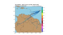
The GFS and its ensembles are in the same boat. They all predict Invest 99L to stay weak and move toward the SOUTHWEST-many have it hit South America.

Could we actually be talking about the same storm? Yup. Interestingly, the Canadian model ensembles are split between solutions close to the GFS and EURO.
WHY ARE THE MODELS SO DIFFERENT?
My theory is that it is about “initialization”-the exact pressures, winds, location of the center, etc. It’s that old saying: “garbage in-garbage out." If you read any of the three articles at the beginning of this blog, you’d know that the EURO does a better job of initialization. This is especially important in weak, poorly organized systems. The level of detail needed to capture the initial conditions accurately is simply better with the EURO.
Now let’s see what happens.


