UPDATE: The wet weather moved out of the area toward daybreak.
The NBC10 Weather Team issued a First Alert for a wet commute Monday morning, with the potential for rain and snow mixing across portions of the region.
A system forced moisture into the region late Sunday night that will last into early Monday morning. This moisture will come at the low temperature point of Monday, early morning. As a result, some neighborhoods will see the rain turn over to snow briefly, mostly points north and west of Philadelphia and the immediate suburbs.
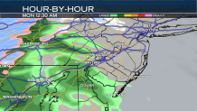
The moisture initially moved in just past midnight along the western edge of the area. It fell as rain initially, because temperatures had not slipped to their low points quite yet.
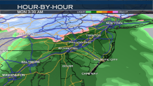
The rain will continue to progress to the east through the early a.m. hours of Monday. At the same time, temperatures will continue to fall to the low 40s to the low 30s and in some areas north of Philadelphia, below freezing. As a result, the rain snow line will cross into the region and some neighborhoods will experience a changeover in precipitation type. The counties most likely to see this in our region are Lehigh, Berks, Montgomery, Bucks and Chester. In Montgomery, Bucks and Chester counties, the northern portions are more likely to see flakes falling. The wintry mix shouldn’t accumulate in those counties, aside from the Lehigh Valley north to the Poconos. A light accumulation of up to an inch is possible there.
Through Philadelphia, New Jersey and Delaware rain is expected. The rain should be primarily light to moderate. Nonetheless, the timing of the system will create slick road conditions across the board which may adversely affect the Monday morning commute. Additionally, if temperatures fall slightly lower than expected, a few flakes may be able to mix into Philadelphia. Models are in good agreement that the rain/snow line will fall just north of Philadelphia. However, slight shifts to the system could allow for Philadelphia to see a brief lived flurry. This scenario isn’t likely, though.
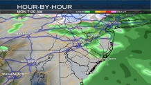
By 8 a.m., most of the rain and snow flurries will begin moving out of the region. Some lingering snow may fall near the Poconos and Lehigh Valley into the later morning. Elsewhere, conditions will begin to gradually dry out.
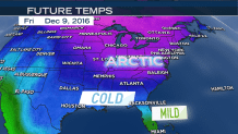
As the work week progresses, there will be several more systems bringing rain potential to the region. The biggest concern, however, will be a blast of arctic air to slope across the entire forecasting area Friday through Saturday. The bitterly cold pattern will bring windy conditions and high temperatures only in the mid to upper 30s. More on that in the days to come with your NBC10 First Alert Neighborhood forecast.