
FIRST: THE SNOW
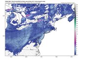
It’s moving our way fast. Here is the way the radar looked Wednesday evening.
Not a very impressive system at all-we can’t even call it a storm. But it’s an area of snow moving into our area while it’s getting very cold. That adds up to widespread, but light snow Thursday night.
The snow should move in around 7 to 9 p.m. with an inch or two expected before midnight.
And it’s going to move so fast, it should be past most of the area before daybreak Friday:

So, that’s about SIX HOURS of mainly light snow-and just about all of it will fall in the middle of the night! That will make it easier for roads to be treated before the traffic picks up early Friday morning.
How much snow? NBC10 First Alert Weather chief meteorologist Glenn "Hurricane" Schwartz expects an average of about an inch, with a few spots picking up 2 inches. Higher elevations in the Pennsylvania counties away from Philadelphia would be expected to get a bit more than the valleys. The wind should also be very light, which is unusual for a snowfall.
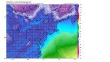
Here is the latest high-resolution map just out Wednesday evening:
DON’T FORGET THE COLD
Arctic air is moving in now, and it’s just going to get colder and colder as we head toward the weekend. Here are predicted temperatures at 7 a.m. Sunday.
Remember, these are temperatures, not wind chills. Glenn expects 15 to 30 mph winds Sunday, so wind chills should be down near ZERO in places.
But, like other cold blasts this season, it’s not going to last for a long time. The warm-up starts Tuesday, and look at the forecast maps for Wednesday compared to normal:

That’s the entire eastern half of the country with WAAAY above normal temperatures! We could even get back to 50-plus degrees that day.
