
We’re in for more wet weather Thursday. When will we finally get a break? NBC10 First Alert Weather chief meteorologist Tammie Souza has the forecast.
What to Know
- The NBC10 Weather Team has issued a First Alert for bands of heavy rain and potential flooding Wednesday.
- Heavy downpours could fall on already saturated ground, causing possible flooding.
- We catch a break this weekend with sunshine and highs near 90 with only isolated showers.
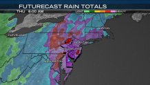
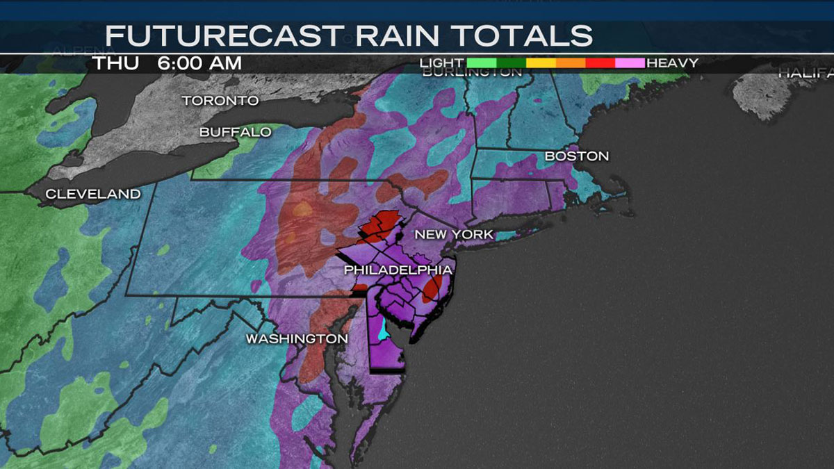
The NBC10 Weather Team issued a First Alert through Wednesday night for potential flash flooding for much of the region, including Philadelphia, the Pennsylvania suburbs, the Lehigh Valley and northern Delaware.
Since Saturday the flow of moisture from the Gulf of Mexico and the Atlantic Ocean has been streaming northward up the east coast bringing periods of heavy rain and thunderstorms.
Between Saturday and Tuesday much of the greater Philadelphia area got 2 to 5 inches of rain, including several localized flooding events.
The communities of Wilmington, Pottstown, Reading and Mt. Pocono reported high amounts of rain. The soil is saturated and any additional rain has nowhere to go other than running off and creating additional flooding issues for rivers, roads and even basements.
You may have been woken up overnight by heavy downpours. A band of heavy rain swept through early Wednesday with many neighborhoods across the region picking up a quick half inch of rain.
Additional moisture streamed into the area Wednesday.

The heaviest rain on the East Coast between now and Thursday morning is denoted on this map with purple and red shades across southeast Pennsylvania and northern Delaware:
Areas in South Jersey, the Jersey shore and southern Delaware saw periods of rain, but were not included in the First Alert for possible flooding.
Local
Breaking news and the stories that matter to your neighborhood.
Most roads were passable for the Wednesday morning commute.

Remember “Turn Around, Don’t Drown” when encountering flooded roads. A foot of water can float most cars and minivans. Also, keep children away from creeks or rivers which are swollen and flowing quickly. Finally, keep an eye out for toppling trees or rocks. The recent rains have loosened the soil in many places.
There is good news… we catch a break this weekend, Saturday and Sunday with sunshine and highs near 90 with only isolated showers.
Next week the wet pattern looks to return to our area.
Stick with the NBC10 First Alert Weather Team on air and on the NBC10 app for the latest on the storms.