
After a couple of days of nothing but clouds, fog, and rain, conditions improved a lot Thursday. Now, we just need to get rid of the wind and boost the temperatures to make the most people happy. And that is just what’s going to happen. Just in time for the weekend.
This is a computer forecast map for Saturday afternoon (other models agree with this).
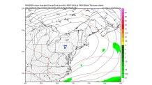
There’s a nice, big H right over Pennsylvania. That assures us of two things: 1) sunshine and; 2) not much wind. The higher the pressure in the HIGH, if it’s centered near us, the more certain the outcome. And a 1040 central pressure is nice and strong. The Sunday forecast map still shows HIGH pressure dominating, although it’s not quite as strong. This should still be enough to hold off any rain or a big cloud increase.
As for temperatures, they will go well above “normal”, especially by Sunday, when we’re expecting it to top 60 degrees. Much of the Eastern U.S. will be warm for December, as the map below shows (compared to “normal”):
WHAT ABOUT NEXT WEEK…& NEXT WEEKEND…& BEYOND?
Local
Breaking news and the stories that matter to your neighborhood.


After experiencing the 2nd warmest November ever recorded in Philadelphia, December is continuing the trend so far. Through the first 4 days of the month, temperatures are running more than 8 degrees above average. And the pattern shows no sign of major changes any time soon.
Here is predicted pattern around 18,000 feet next Friday, Dec. 11. As we’ve shown before, this type of map shows wind flows along the lines. So start in Philadelphia and see where that line starts. Almost halfway through the month, and our air can still be traced back to the Central Pacific. You can’t get any arctic air from there!
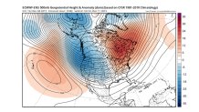
At the same time, look at the lower atmosphere temperature map (below), with readings compared to normal (called “anomalies”). While our area has been in a very mild pattern relatively speaking, there is an exceptional-even record-breaking lack of cold air across the Great Lakes, Upper Midwest, and much of Canada!
[[360642531, C]]
The only parts of the country colder than normal are Alaska and part of California. Even if our air could magically start coming down from Canada, it still can’t be very cold. This pattern will take a LONG time to change. In the meantime, we can save on heating bills. But snow lovers will continue to be sorely disappointed.
