
AN EAST COAST STORM THREAT
Whether it’s a Hurricane, Tropical Storm, or Nor’easter, a significant storm will affect much of the East Coast over the next several days. This is a very complex setup, but as mentioned yesterday, this is an extreme weather pattern that is setting up, leading to the potential for flooding in some areas.
AN EXTREME PATTERN
Of course, people want to know exactly where a storm is going to hit, how strong it will be, and how bad the rains will be. It’s too complex a situation to go into those details. But that doesn’t mean we should stay quiet about “potential” and the overall pattern that is setting up. Let’s look at that pattern.
Watching LIVE on #Periscope: NBC10 Weather Talking heavy rain, coastal flooding and a Hurricane Joaquin update https://t.co/QCvnlW2bKe
— NBC10 Philadelphia (@NBCPhiladelphia) October 1, 2015When we talk about "patterns," we’re usually talking about conditions high up in the atmosphere. Meteorologists use the level close to 20,000 feet above the ground (for reasons not important here).
We also look for "anomalies": changes from the average pattern. With that in mind, here’s the upper-air map for Saturday morning from the European model-the world’s overall best. It looks a lot like the map I showed yesterday.
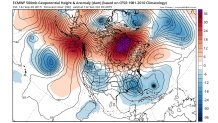
The colors show the extremes. The red and purple in Canada represents extremely high pressure. And the dark blue in Georgia represents extremely low pressure. This is a classic "blocking pattern." Past patterns like this have led to disastrous flooding in many parts of the world.
Local
Breaking news and the stories that matter to your neighborhood.


Meteorologist Stu Ostro of The Weather Channel has done a lot of research into these patterns, which seem to be happening more in recent years. No one should want this pattern to verify.
Even a weaker version would likely lead to serious flooding somewhere along the East Coast. We can’t say WHERE the floods will occur, but the POTENTIAL is there.
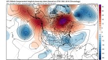
The main U.S. model, the GFS, like other models we saw today, shows an extreme pattern, too-more like the European than it did yesterday.
OH, YEAH … THE STORM
We often get so focused on a storm or hurricane that we overlook the pattern. So that’s why I started with it. The storm gets too much “credit” for the disastrous results. If it weren’t for the extreme blocking pattern over the North Atlantic, the name "Sandy" would be just another one of hundreds of names of hurricanes that curved out to sea. The block is what caused the left turn that led to the disaster.
Tropical Storm Joaquin formed last night in the Atlantic, well east of the Bahamas. Normally, a storm in this position at this time of year moves harmlessly out to sea, but not this time. Many computer models are showing some type of left turn toward the East Coast, even if it doesn’t happen until the weekend.
A TRIPLE THREAT
Here’s another reason we can’t just focus on Joaquin. Even before that storm would affect us, we have the rain from Tuesday night, and then another big round Thursday into Friday due to a stalled front. Some places could see several inches of rain even before Joaquin moves this way (if it does). That would make a triple rain threat.
These unusual and extreme patterns tend to bring some surprises. A few computer models suggest that Joaquin stays out in the ocean, but a type of Nor’easter develops along the East Coast, bringing heavy rain up our way. In a way, it doesn’t matter if it’s a Tropical Storm or Nor’easter. It’s going to get wet and windy.
Even if the storms stay south of us, we’ll feel some effects. With massive high pressure to the north, the pressure difference (or “gradient”) will be big, leading to strong east winds up and down the coast. They’ll be piling water up to the coast. The stronger the winds and the larger stretch of ocean they cover (the “fetch”) will determine how much coastal flooding and beach erosion will result. And it doesn’t help that we’ve had already huge amounts of coastal flooding and beach erosion in some parts of the East Coast in the past week.
Stay tuned for another update tomorrow.
