It's time to soak up the sun, but don’t put your coats in the attic just yet. Although Saturday will be warm and sunny, a cold front will arrive Sunday with a 30-degree temperature drop.
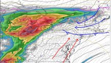
SATURDAY MORNING FORECAST
That's when the Philadelphia area will experience a "back-door front," which is cold air that comes from the northeastern United States. (Think Boston.) This front will bring the plummet, along with clouds and patchy rain or drizzle throughout the day. Temperatures will stay in the 40s most of the day through much of the area.
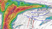
SUNDAY MORNING FORECAST
On Sunday evening, the front will continue south, while another begins to come in from Chicago. These two fronts will converge Sunday night, leaving Monday morning stormy. That is why we’ve issued a First Alert, starting at 4 a.m. Monday through 12 p.m. Heavy rain and possible gusty thunderstorms will complicate the morning rush hour.
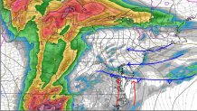
SUNDAY AFTERNOON FORECAST
The coldest day of the week will be Tuesday, when gusty winds will make temperatures in the 40s seem even colder. After that, temperatures will return closer to seasonal averages, with highs mainly in the 60s.
Local
Breaking news and the stories that matter to your neighborhood.