
Updated 10:35 p.m. Thursday, October 1:
NBC10 First Alert Meteorologist Sheena Parveen is putting a First Alert in effect for Friday and Saturday due to a coastal flood warning and watch for our area.
Rain and wind will intensify Friday with winds gusting as high as 50 mph along the shore and 35 mph inland. Periods of heavy rain will move onshore throughout the day and could bring coastal flooding because of the amount of time the winds will last.
The shore could see beach erosion with possible 3 foot storm surge with the high tide from about 10 a.m. to noon. It will stay cool Friday with temperatures in the mid to upper 50s.
The rain will last into Saturday, although the rain may not be as heavy on Saturday, the winds will persist especially along the shore. There will continue to be periods of rain Saturday with winds gusting 30-35 mph inland and 45+mpg along the shore. Temperatures will be in the mid 60s.
Sunday will also be a windy day, cloudy with showers hanging around.
Watching LIVE on #Periscope: NBC10 Weather Talking heavy rain, coastal flooding and a Hurricane Joaquin update https://t.co/QCvnlW2bKe
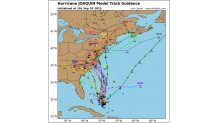
— NBC10 Philadelphia (@NBCPhiladelphia) October 1, 2015Tracking Hurricane Joaquin's Possible Tracks
By Monday is when we need to watch for Joaquin. At this point (Thursday 10 p.m.), Joaquin looks to pass well offshore. This is subject to change, but more models are suggesting a turn out to sea.
Stay with NBC10 for continuing updates on Joaquin.
Older Posts:
AN EAST COAST DOUBLE WHAMMY….
An umbrella, optional today, will become necessary tomorrow and into the weekend. First up is the Nor’easter that got started today and will intensify tomorrow. Rain is expected to be heavy at times tomorrow and into tomorrow night. It could bring much of the region 1 to 3 inches of rain.
Winds will be strongest at the shore and, with the potential of heavy rainfall, coastal flooding is likely around mid-day high tide tomorrow. It could continue to be a problem through the weekend for shore communities.
Local
Breaking news and the stories that matter to your neighborhood.


LET’S TALK HURRICANE JOAQUIN
Joaquin is now a major hurricane and is forecast to strengthen tomorrow morning. It is continuing to batter the central Bahamas now and will keep doing so through tomorrow morning.
The key question is what happens once it finally starts moving north. Joaquin will start to make his move later tomorrow and will continue moving north up the east coast of the U-S over the weekend and into next week.
The big question mark has been whether Joaquin turns left or turns right. Over the past few days, many models have been predicting a left turn, bringing Joaquin directly into the east coast.
But the European model has been the lone objector to this scenario, up until now. The Euro, as we call it, accurately predicted Hurricane Sandy days before it made landfall. For days, the Euro has been suggesting Joaquin will go right, away from the coast. Now, other models are starting to fall in line with the Euro.
This is an encouraging sign, but not a done deal. For now, the National Hurricane Center is going down the middle of this forecast road.
It still gives Joaquin a shot at an east coast hit but not a guarantee. It’s just enough to keep people planning for the worst with encouraging signs that the worst might not happen this time around.
Earlier Posts:
AN EAST COAST DOUBLE WHAMMY….
Hope you enjoyed the brief dry patch Wednesday, because an umbrella will become a permanent part of your daily routine for at least the next several days. First up is a Nor’easter. Rain starts on Thursday, but picks up Friday into Saturday with several inches likely. We’re going with a general two to four inches but the Shore could see five or even six inches of rain along with some serious coastal flooding. The storm surge in Atlantic City on Friday is projected to be around three feet. This first low will cause flooding both at the shore and around the Philadelphia metro area and that’s all before we even talk about the tropics.
- Track rain with NBC10's Live Interactive Radar
AN EXTREME PATTERN….
Before we talk about the specifics of where Joaquin will be going, and how it will affect us, it is important to take stock of the overall pattern. Here’s a recap from yesterday’s blog ICYMI…
When we talk about “patterns," we’re usually talking about conditions high up in the atmosphere. Meteorologists use the level close to 20,000 feet above the ground (for reasons not important here). We also look for “anomalies”: changes from the average pattern. With that in mind, here’s the upper-air map for Saturday morning from the European model-the world’s overall best. It looks a lot like the map I showed Monday.
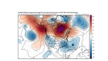
The colors show the extremes. The red and purple in Canada represents extremely high pressure. And the dark blue in Georgia represents extremely low pressure. This is a classic “blocking pattern." Past patterns like this have led to disastrous flooding in many parts of the world. Meteorologist Stu Ostro of The Weather Channel has done a lot of research into these patterns, which seem to be happening more in recent years. No one should want this pattern to verify. Even a weaker version would likely lead to serious flooding somewhere along the East Coast. We can’t say WHERE the floods will occur, but the POTENTIAL is there.
ALRIGHT, LET’S TALK JOAQUIN….
We often get so focused on a storm or hurricane that we overlook the pattern. So that’s why I started with it. The storm gets too much “credit” for the disastrous results. If it weren’t for the extreme blocking pattern over the North Atlantic, the name “Sandy” would be just another one of hundreds of names of hurricanes that curved out to sea. The block is what caused the left turn that led to the disaster.
Joaquin is now a Hurricane and it continues to strengthen. This is a storm that was barely on our radar (pardon the pun) on Sunday, had just become a Tropical Storm Tuesday and now it is a Hurricane and it’s starting to look a lot more organized. Every minute the storm spends over the warm waters near the Bahamas, the stronger it gets. The key question is what happens once it finally starts moving north.
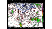
Wednesday’s afternoon model run showed a pretty good consensus on where the models think the storm is going to go. For the most part, they’re suggesting a left turn (if that sounds familiar, it should) but the track is much closer to North Carolina and Virginia than it is for our area.
If this happens, we avoid a direct hit, but still get all of the negative effects of the storm, including even more rain (on top of what we pick up from the Nor’easter) and storm surge, especially for the Delaware beaches and Cape May county. The area that gets hit worst during a hurricane landfall is always the area to the northeast, also known as the “dirty quadrant.” That’s why Ocean & Monmouth got hit harder by Sandy than Cape May…the storm made landfall near AC, and places like LBI and Seaside were to the north and east. Landfall near North Carolina means that the tidewater of Virginia and DelMarVa get hit the worst, with points farther north in New Jersey feeling some impacts, but less than a landfall farther up the coast.
Even if the storms stay south of us, we’ll feel some effects. With massive high pressure to the north, the pressure difference (or “gradient”) will be big, leading to strong east winds up and down the coast. They’ll be piling water up to the coast. The stronger the winds and the larger stretch of ocean they cover (the “fetch”) will determine how much coastal flooding and beach erosion will result. And it doesn’t help that we’ve already had huge amounts of coastal flooding and beach erosion in some parts of the East Coast in the past week.
THE KING SAYS OTHERWISE….
There is another option, the Euro. King of the models. Predictor of Sandy. Widely beloved model by all of the meteorologists in all of the land. The European takes Joaquin out to sea and limits us to just a lot of rain.
But wait, you might be saying, didn’t you say earlier that big block forces the storm to us? Yes. But…the Euro brings in an interesting solution. Not likely, but plausible and because it is the Euro, we have to entertain it. The Euro suggests that Joaquin will mix with a disturbance that are the remnants of Ida. In that scenario, the Fujiwhara effect comes into play and Joaquin orbits Ida and moves (relatively) harmlessly out to sea. More on that Thursday, where we’ll hopefully know a lot more about the track.
Stay tuned…
Tracking Hurricane Joaquin's Possible Tracks
Stay with NBC10.com for the latest weather updates.
