
ANOTHER JANUARY 22-23, ANOTHER BIG NOR’EASTER
It may be pure coincidence, but exactly one year after our only snowstorm of last winter, here comes another big nor’easter. This time, though, it’ll be too warm for snow.
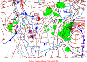
Here is what the weather map looked like on January 23rd, 2016:
Now, take a look at the predicted map for January 23rd-exactly one year later:
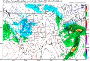
Looks awfully familiar, doesn’t it? It takes more than an intense LOW along the Mid-Atlantic coast in the middle of winter. This January has been MUCH warmer than last year, especially in the days leading up to the big storm.
Local
Breaking news and the stories that matter to your neighborhood.


Last year This year
HIGH LOW HIGH LOW
19th 29 16 49 43
20th 36 21 48 43
21st 37 26 54 45
As you can see, it’s not even close to being cold enough for snow-even at night.
People often ask: “How much snow would we have gotten if it was snow instead of rain?” Usually it’s not a good comparison, since warm air can hold so much more moisture than cold air. There’s just going to be WAAAY more moisture around this time because of the warmer air. But, considering the pattern (including a giant area of HIGH pressure over Eastern Canada), I can easily imagine another two foot near-blizzard for our area.
SO WHAT WILL HAPPEN THIS TIME?
Even without snow, this is going to be a big storm. The pressure difference between the LOW and the HIGH will lead to a strong onshore flow. Here’s a close-up of the forecast map:
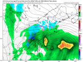
The lines represent areas of equal pressure (called isobars). The closer they are together, the stronger the winds. Another factor will be the slow movement of the storm itself. That means more and more hours of onshore flow than in a typical coastal storm.
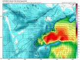
There won’t be a lot of rain from the system moving through Friday. So the “total accumulated precipitation” map consists mostly of the rain Sunday into Tuesday. Parts of our area are in the 3” range, which is a LOT of rain.
And now for the wind. It will be coming from the Northeast, and this model shows sustained winds at the coast of nearly 40 knots (46 mph). In that case, gusts would be well over 50 mph. When you combine such strong winds with the very wet ground, some trees could go down.
THE COASTAL FLOOD THREAT
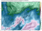
Notice the wind barbs on the above map. They show both wind direction and speed. The map shows hundreds of miles of a wind from the East out in the Atlantic. That piles up water, and the waves get bigger and bigger as they approach land. The longer that wind direction continues, the bigger the waves, too. Each high tide means a higher water level. It all adds up to a significant coastal flood threat if the forecast maps are right.
We’ve issued a FIRST ALERT for the entire area for the period Sunday afternoon through Monday night for the combination of heavy rain, strong gusty winds, and coastal flooding. Stay tuned for updates on this significant storm.
