What to Know
- Two winter storms are expected to hit parts of our area later this week.
- The first winter storm is the weaker of the two and will bring a wintry mix on Thursday night and rain most likely on Friday morning.
- The second winter storm is significant and will impact the entire East Coast Saturday night through the day Sunday.
Winter is making up for lost time with not one, but two winter storms later this week followed by what could be the coldest air we've had in 25 years.
The biggest uncertainty for both storms is the location of the rain/snow line, which may bisect the Philadelphia area at times leaving some neighborhoods in rain and others in snow.
The first winter storm is the weaker of the two and will bring a wintry mix Thursday night and Friday morning, with the best chance for accumulating snow north and west of Philadelphia. Light rain and snow will end Friday morning.
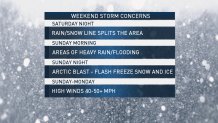
The second winter storm is significant and will affect the entire East Coast. The latest track shows a combination of snow, turning to heavy rain, turning back to snow across our area from Saturday evening through Sunday night. What you get will depend on where you are.
Local
Breaking news and the stories that matter to your neighborhood.


The video below shows you that a 100-mile shift in the storm track means the difference between rain and snow.
There will be strong winds both Sunday and Monday, with gusts as high as 50 mph.
As the cold front passes Sunday, temperatures will quickly plummet 20 to 30 degrees into the teens, changing rain back to snow. The snow finally ends Sunday night, but the temperatures keep on falling.
Any moisture left on the ground will likely freeze.
That cold air will be the coldest of the season so far, with a low temperature in the single digits and highs in the teens on Monday. The wind chill will remain well below zero all day. If the temperature drops to zero, it will be the first time that has happened in Philadelphia in 25 years, First Alert Weather meteorologist Bill Henley said.
TIMING: Storm No. 1 Thursday evening through Friday morning. Storm No. 2 Saturday night through Sunday night.
WHAT: Periods of heavy rain and snow. A large temperature difference is possible from the Jersey Shore to the Lehigh Valley. The rain/snow line could waver back-and-forth across the entire area several times. Frigid air arrives Sunday night. Dangerously cold Monday. Very windy on Sunday and Monday.
IMPACTS: These will vary from neighborhood to neighborhood. Heavy rain could create localized flooding. Snow totals could widely vary and will create slippery roads. Winds could knock out power or topple trees and travel could be impacted across the region.
The storm track could shift slightly north or south and the timing may slow or speed up by a few hours which could mean the difference between you shoveling heavy snow or needing your rain gear. Our team of First Alert meteorologists will keep you updated with the latest forecast here and on air and on the NBC10 APP so you will be prepared for rain, snow or both in your neighborhood.