
Only Temporary Cooling
Even though the average high temperature in Philadelphia in October is 68 degrees, we’ve had more days in the 80s than in the 60s. Actually, it’s THREE TIMES as many 80s as 60s! So far, temperatures are running close to 9 degrees above average for the month. In Allentown, it’s more than 10 degrees above average.
A couple of days in the 60s Thursday and Friday are not putting much of a dent in the abnormally warm month. And even some more 60s early next week won’t have much impact. The overall pattern has been warm, not only around here, but for the entire eastern half of the country.
Here are the maps for the past 2 weeks:
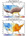
The bottom map clearly shows colder than normal air in the west along with the warmer air in the east. That is obviously a sign of a particular weather pattern. And, here it is-at about 18,000 feet up, which is the main level meteorologists use to analyze weather patterns:
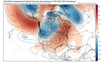
The red areas represent above normal pressures, and the blues, the opposite. This is a warm pattern, no matter what time of year. In summer, it’s the pattern of heat waves. In winter, it’s a pattern where no snow is possible.
Local
Breaking news and the stories that matter to your neighborhood.


Of course, these weather maps change from day to day. But if a pattern is "locked in", after each time it changes significantly, it changes right back to the prevailing pattern. That’s how we can get a couple of chilly days, but then warm right back.
Is This 'Indian Summer'?
You may have already heard this pattern described as "Indian Summer." But in our part of the country, meteorologists consider it: "a spell of warm weather after the first frost." That term supposedly goes back to 1778. It’s hard to describe our current weather that way, since our temperatures haven’t even gone below 49 degrees yet! A frost? Not even close.
Will the Pattern Change Soon?
Not in the next week, at least. Even though we’ll cool off Monday and Tuesday, the rest of next week should feature above normal temperatures. Here’s that upper-air pattern for next Saturday:
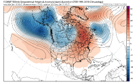
Look familiar? That’s a lot like the current pattern. As long as all those blues are near Alaska, the reds will continue in the Eastern U.S.
Here is another model showing surface temperatures compared to normal next Saturday:
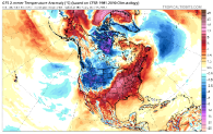
Warm in the east; cold in the west. Again.
