
Flash flood warnings were in effect Sunday morning as Henri passed off the coast, with hours of drenching rain expected.
The NBC10 First Alert Weather Team has issued a First Alert lasting through Sunday for the Jersey Shore and Delaware beaches because of the slow-moving Henri, which weakened slightly to a tropical storm before again becoming a hurricane. Though it wasn't making a direct hit over the region, it was still causing potentially dangerous impacts,
Flash flood warnings were in effect through 8 a.m. for for Hunterdon and Ocean counties in New Jersey. Warnings were also issued for Hamilton Square, Trenton and Freehold through 11 a.m. Meanwhile, flash flood watches were issued for areas from the coast all the way to the Lehigh Valley in Pennsylvania, with rain expected to last through Monday morning.
Along the coast, people should avoid getting into the water due to big waves and dangerous rip currents.
Get Philly local news, weather forecasts, sports and entertainment stories to your inbox. Sign up for NBC Philadelphia newsletters.
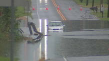
Similarly, people should avoid attempting to drive through high water. In East Windsor, New Jersey, NBC10 cameras captured a car stranded on Route 33 as water rose to the top of its tires.
The National Weather Service said Saturday that the risk of rip currents across all New Jersey and Delaware beaches could last through Monday.
Local
Breaking news and the stories that matter to your neighborhood.


Henri could make landfall somewhere from central Long Island to Cape Cod. If it tracks farther west, that would bring the storm closer to the Philadelphia area and New York City.
Download the free NBC10 app now to get the latest forecast for your precise location. Turn on tropical tracks in the interactive radar layers to watch the latest Henri track.
