
What to Know
- The hottest temperatures we have seen in years have rolled and will build to dangerous heat levels by the weekend.
- Storms packing downpours and leading to possible flooding moved in Wednesday evening and should last into early Thursday.
- Seek shelter in air conditioned spaces and be sure to check on vulnerable neighbors and family members.
Editor's Note: For the latest on steamy and stormy conditions Thursday, click here.
A one-two punch hit our region Wednesday with the hottest temperatures we've seen in years as well as severe storms that caused damage and flooding.
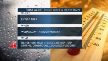
We have a two-part First Alert for the entire Philadelphia region through the weekend. Dangerous days of heat began Wednesday afternoon. Heavy, drenching rain, with localized flash flooding, also moved into parts of the area Wednesday evening.
Temps on Wednesday morning were already around 80, with sticky conditions around daybreak. By midday some neighborhoods already had temps hitting the mid 90s with a feels-like temperature around 105.
The steamy conditions built through the day before the remnants of Barry rolled in the late afternoon in some neighborhoods.
A Severe Thunderstorm Warning was in effect for Berks, Chester, Delaware, Philadelphia and Montgomery counties in Pennsylvania, Atlantic, Cape May, Cumberland, Gloucester and Salem counties in New Jersey, and Kent and New Castle counties in Delaware.
There were multiple reports of water rescues and homes being struck by lightning in Berks County as well as downed poles and wires on cars in Chester County, Wednesday night.
Thursday there will be periods of drenching rain courtesy of the remnants of Barry. Localized flooding is a concern. Temperatures will be near 90 with a feels-like near 100. Scattered storms could hit throughout the day.
Friday, Saturday, Sunday and Monday the heat and humidity make a bigger jump with highs between 96 to 101, lows in the 80s and a feels-like possibly topping 115. The high Saturday could hit a record at 101.
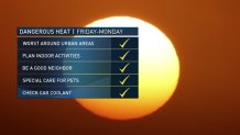
The weekend will be the most dangerous time because the cumulative effect of the heat will wear on your bodies. Please plan for time indoors using the air-conditioning or a fan with the windows open, check on neighbors and the elderly, use special care for pets and check the coolant levels in your car. And, don't forget to wear sunscreen.
Local
Breaking news and the stories that matter to your neighborhood.


An excessive heat warning is in effect for the urban areas of Philadelphia, Wilmington, Trenton and surrounding suburban areas through Sunday night, the National Weather Service said.
The City of Philadelphia also issued its first heat health emergency of the summer, joining other area communities, including Camden, Mercer and Montgomery counties and Wilmington, in launching initiatives for helping people more susceptible to the heat.
"We strongly urge the public to visit older friends, relatives and neighbors to ensure that air conditioners or fans are working and homes are adequately ventilated," Philly Health Commissioner Dr. Thomas Farley said. "In a heat wave, the majority of the victims are older people and those with pre-existing medical conditions."
The only place where you might get some relief from the heat is at the beach, where the strong sun will pose its own risk.
Make plans to spend time indoors and check on neighbors to make sure they are OK during the heat wave. Take special care for pets too.
THURSDAY: Hot and humid. Thunderstorms possible. High around 90. Feels like 100.
FRIDAY: Tropical heat and humidity. High in the upper 90s. Feels like 105 to 110.
SATURDAY: Blazing sunshine. Tropical heat and humidity. High around 101. Feels like 115.
SUNDAY: Mostly sunny, hot and humid. High nearing 100. Feels like 110 to 115
MONDAY: Hot and humid. High in the mid 90s. Feels like triple digits.
Follow the NBC10 First Alert Weather team and download the NBC10 app to keep ahead of the dangerous heat and storms.
