
A flash flood warning early Monday ended by first light, but cold and cloudy conditions are here to stay for the end of the long holiday weekend.
The cold front initially slid into the region Sunday morning from the northeast. This combined with moisture and rain triggered heavy downpours, lightning and flash flooding over the Pennsylvania suburbs and in central New Jersey. In fact, some parts of Bucks and Mercer counties saw between 3 and 6 inches of rain in only a few hours. Water rescues were required.
Local
Breaking news and the stories that matter to your neighborhood.


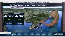
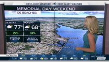
Memorial Day will be cloudy, but mostly dry as temps push into the mid to upper 70s for remembrances and parades. At the shore points, temps will be closer to 70 and we can't rule out a spotty shower.
A Flash Flood Watch for much of the Southern half of our region was in place through 4 a.m. Monday morning.
The rain was so heavy that the National Weather Service issued a series of Flash Flood Watches and Warnings through Sunday. A Flood Warning was issued for the Assunpink Creek in Trenton as well.
The temperature in Philadelphia dropped into the upper 60s by the afternoon, while Atlantic City dipped below 65 degrees.
The Delaware beaches remained one of the warmer spots with temperatures in the mid-70s by the evening.
By Tuesday, the sun should return as temps push into the 80s. Tuesday will be considerably humid again, too.
