
Click here for the latest on the coming storm.
Following the extreme winds and pounding snow Friday, the greater Philadelphia region should begin prepping for another coastal low that could arrive Tuesday night and last through Wednesday.

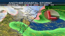
Computer models, which meteorologists use to assist their forecasting, are beginning to agree on the development of storm system just offshore. When computer models come into better agreement over the development of a storm, it leads to higher confidence the event will indeed happen. For now, we believe the system will begin to impact our region Tuesday night.
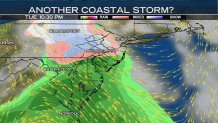
The model above (the GFS, also known as the American model) indicates the system begins with a rain/snow mix around the I-95 corridor, rain farther south, and snow over the PA Suburbs, Lehigh Valley and Berks County. Other models begin with a bit more rain before colder air is forced into the region by the storm.
The model keeps the rain/snow line along the I-95 corridor through the night, and into Wednesday morning. Again, some models differ on the exact placement of the changeover line. Notice the coastal low starting to develop off the Carolina coast.
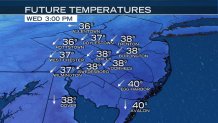
As the day progresses, it’s likely that the storm will force cold air down. If the storm is powerful enough, this cold air will start to turn rain to snow farther south. Notice the forecast temperatures Wednesday afternoon are very similar to last Friday’s storm: borderline—in the mid- to upper-30s.
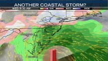
The American model has the changeover occurring in the afternoon down to portions of South Jersey. At this same time, the coastal low will intensify and slide closely past the Jersey Shore. Depending upon HOW close the storm center passes, heavier snow and rain is possible across the region. This could lead to accumulating snow. In addition, winds will strengthen.
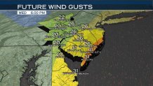
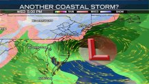
Wind gusts will be strongest against the shore where gusts above 40 mph are possible. Minor coastal flooding may again become a threat. Farther inland, gusts between 25 and 35 mph are likely. Notice these winds will NOT be as powerful as the storm last Friday. As a result, wind damage is not as likely. However, previously damaged or weakened trees or buildings may be impacted by these gusts.
Overnight the system may continue to drop snow, but as the Nor’Easter pulls away from our region, the snow will become lighter.

By Thursday morning, it appears the region will begin to dry out. Some models continue to bring snow around the backside of the storm throughout Thursday morning. At this point, we believe everything will clear more quickly.
Local
Breaking news and the stories that matter to your neighborhood.

Right now, models differ greatly on snow totals. As a result, we’re still working on fine-tuning our forecast amounts. Regardless of the totals, the commutes both Wednesday morning and ESPECIALLY Wednesday evening will be difficult. Once the team updates their forecast, we’ll bring those updates to you on air, and online.
