
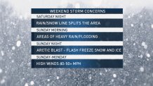
What to Know
- A weekend winter storm is expected to hammer the Philadelphia region with a dangerous mixture of heavy snow, ice and rain.
- Heavy snow will begin moving into the region Saturday afternoon. Some areas will then get snow and ice, and others will get heavy rain.
- Temperatures begin plummeting to dangerously cold levels later Sunday and continue through Monday.
A weekend winter storm is expected to hammer the Philadelphia region with a dangerous mixture of heavy snow, ice and rain. But the storm's effects will vary widely depending on where you live, and will make travel treacherous.
The dangerous conditions prompted Pennsylvania Gov. Tom Wolf to declare a statewide emergency and issue speed restrictions, as well as a "ban on all commercial traffic, including buses on most interstates and the Pennsylvania Turnpike." The declaration allows for increased help for storm-related needs.
A First Alert is in effect through Monday, which is also the Martin Luther King, Jr. holiday, due to the winter weather.
Here is the latest breakdown from the First Alert Weather Team:
The Storm - Saturday evening through Sunday night
Starting Saturday afternoon, heavy snow will begin moving into the region from the west. By the evening, warmer air will move up from the south, potentially turning snow into ice.
The areas most in danger of experiencing heavy icing and freezing rain will be to the north and west of Philadelphia. The ice is expected to begin forming early Sunday morning. This combination will create a danger of power outages as heavy snow and ice accumulate on power lines and tree branches.
Philadelphia and areas further south, like South Jersey, the Jersey Shore and southern Delaware will be less affected by snow, but could see several inches of heavy rainfall, creating a risk of floods. These areas could also expereince a rain-snow mix. As Arctic air rushes in later on Sunday, any leftover moisture will quickly freeze -- slush will likely turn to ice on roads and sidewalks.
The sooner you shovel, especially in northern and western suburbs, the better as whatever snow is on the ground will harden as temps quickly drop.
It's still too soon to predict how much snow and ice could fall.
Dangerous Cold - Late Sunday through Monday night
The coldest air of the winter season so far will plunge our neighborhoods into a deep freeze later Sunday as winds, with gusts above 40 mph possible, blow. Low temperatures are expected to rest in the single digits and highs in the teens on Monday.
Making matter worse, the wind chill will remain well below zero all day, but it'll feel 10 to 20 degrees below zero.
Local
Breaking news and the stories that matter to your neighborhood.

Any moisture left on the ground will freeze, making for potentially treacherous travel Monday.
[NATL] 6 Essential Life Hacks for Surviving Cold Winter Weather
This Arctic blast will come on one of the most popular days for volunteerism: Martin Luther King, Jr. Day. Outdoor activities are likely to be moved or canceled.
The African American Museum in Philadelphia hopes to get people inside as quickly as possible Monday. Other groups are also making plans for the cold. Keep an eye on social media and reach out to organizations to learn of any changes to volunteer opportunities.
Temps still won't break the freezing mark Tuesday when sunny skies push the high temperatures into the upper 20s. Relief from the cold finally comes on Wednesday with high temps pushing into the 40s.
Our team of First Alert meteorologists will keep you updated with the latest forecast here and on air and on the NBC10 App so you will be prepared for rain, snow or both and bitter cold in your neighborhood.
