When it comes to winter, the NBC10 First Alert Weather Team uses a lot of terms to describe precipitation. There’s rain, snow, sleet, even freezing rain! But why do some areas see different types of precipitation than others? It’s all about what’s going on up in the sky!
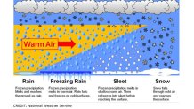
Take a look at the image below.
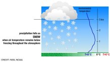
Temperatures are typically much cooler high in the sky than they are on the ground. That means that when precipitation forms in the clouds this time of year, it begins as snow.
When a flake falls from the cloud, it passes through air that may gradually warm as the flake falls to the ground.
If the temperature is still near or below freezing at the surface, then the flake lands on the ground as snow. It’s frozen precipitation.
How about the opposite?
Local
Breaking news and the stories that matter to your neighborhood.

If a snowflake falls into an area of warm air (above 32 degrees), then it melts. If the warm air continues all the way to the ground, then the precipitation is called rain. It’s liquid precipitation.
Now let’s talk about the “tricky” forms of winter precipitation.
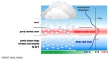
Sometimes, warm air will wedge into the atmosphere. It may just barely slice into the sky, or it may take up a good period of the flakes’ fall. You can see this example in the image above. This results in two different “wintry” conditions.
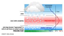
When the snowflake falls from the sky into an area of warm air, it melts into a raindrop. However, sometimes a thin layer of very cold air hugs the ground. If the rain drop enters the cold surface air (near or below 32 degrees) the raindrop may become “supercooled." This means it doesn’t have enough time to freeze, but it’s cold enough too. Once it hits a cold object like a tree, power line, vehicle, or road, it freezes. This type of precipitation is called freezing rain. This is especially hazardous because it can create black ice, or cause tree limbs to snap due to the added weight from the ice.
Now, if the warm air just barely slices into the column of air the flake falls into, it has a different effect on what we see on the ground. The snowflake may melt or partially melt once it enters the warm air, and turn into a raindrop or slush. However, if it enters a period of colder air again as it continue to fall and has enough time, it will refreeze into a frozen raindrop. This isn’t the same as a snowflake, because it formed differently and its structure is different. It’s literally a frozen drop of water. This is called sleet. Sleet typically bounces, but can accumulate into piles. You can remember this by remembering the phrase “sleet has a beat." You can hear it!
So why is this important for us?
We often see different types of precipitation in different neighborhoods! Colder areas (Poconos, Lehigh Valley, Berks, and even the PA Suburbs) more often see snow in winter. That’s because these areas regularly keep temperatures near freezing during precipitation events. So, the precipitation hits the ground as snow.
However, during some storms, warmer ocean air will wedge into our atmosphere. Last March (2016), this occurred. The result? The shore saw rain, portions of Delaware, New Jersey and Philadephia saw sleet and freezing rain, and portions of the PA Suburbs and Lehigh Valley/Berks Co/Poconos saw snow! The warm air thinned as it stretched inland, and created a major ice storm for some and snow storm for others. That’s why we do neighborhood weather. We don’t all see the same thing, because we aren’t all dealing with the same atmospheric conditions!