
GUSTY WINDS CONTINUED TUESDAY
Here are the peak wind gusts in parts of our area Monday (from NWS)
***********************PEAK WIND GUST***********************
LOCATION MAX WIND TIME/DATE COMMENTS
GUST OF
MPH MEASUREMENT
DELAWARE
...NEW CASTLE COUNTY...
NEW CASTLE COUNTY AI 46 315 PM 11/21 ASOS
NEW JERSEY
...CAPE MAY COUNTY...
19 SSE PORT NORRIS 49 1236 AM 11/21 NOS-NWLON
...GLOUCESTER COUNTY...
12 E ELMER 47 110 PM 11/21 NJ-MESONET
...MIDDLESEX COUNTY...
3 WSW TOTTENVILLE 46 1239 AM 11/21 WXFLOW
...MONMOUTH COUNTY...
KEYPORT 53 101 AM 11/21 TRAINED SPOTTER
7 N LONG BRANCH 52 1240 AM 11/21 WXFLOW
8 SE HUGUENOT 50 1246 AM 11/21 CWOP
...SUSSEX COUNTY...
HIGH POINT 60 240 PM 11/21 NJWXNET
PENNSYLVANIA
...BERKS COUNTY...
READING REGIONAL AIR 49 303 AM 11/21 ASOS
...CHESTER COUNTY...
4 ESE COCHRANVILLE 50 1135 AM 11/21 DEOS
...MONROE COUNTY...
POCONO MOUNTAINS MUN 52 142 AM 11/21 ASOS
...MONTGOMERY COUNTY...
3 SSW SCHWENKSVILLE 52 230 PM 11/21 CWOP
...PHILADELPHIA COUNTY...
NORTHEAST PHILADELPH 51 140 PM 11/21 ASOS
Officially, our peak gust at Phila. International Airport was 47 mph. Harrisburg, PA had a gust of 54 mph Monday afternoon.
Tuesday was also a windy day, but gusts reached 35 mph-not quite as much as Monday.
THE LAKE-EFFECT SNOW MACHINE GETS TURNED ON
Lake-effect snows are most spectacular both early and late in the season, when the lakes are unfrozen and relatively warm. They are warmer in November than in spring, so this is the time of year when they can get snow measured in FEET. The radar shows the direction of the wind….
And if the wind direction doesn’t change, that same narrow band of heavy precipitation stays in the same area.
The bottom line for travel: DON’T DRIVE UP I-81 FROM PENNSYLVANIA INTO NEW YORK STATE! It’s like a blizzard up there!
HOLIDAY TRAVEL OUTSIDE THE LAKE-EFFECT AREAS
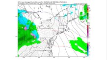
Those traveling between Tuesday and Thanksgiving Day will be pretty lucky. A weak weather system will be moving eastward across the area, but it should be warm enough for rain showers (not snow) from Chicago through Cleveland through Pittsburgh. And much of New England will be dry through Wednesday.
Here is a computer forecast map for Wednesday afternoon:
On Thanksgiving Day, some of the moisture moving from Chicago will be moving into New England, bringing the chance of at least some light snow.
Here’s the map for Thursday afternoon:
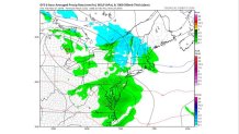
The blue area is light snow, and the light green area is light rain. This model tends to overdo the precipitation, so I only expect some spotty light showers in our area.
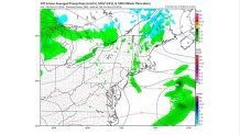
By Friday, this system is gone, and dry weather returns:
Stay tuned for more as the first big holiday weekend of the season nears.
