WHAT’S CHANGED:
There are two major changes to the NBC10 forecast… timing and total snow.
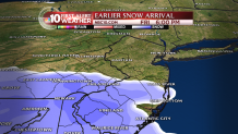
The first critical update is timing… snow may start falling in and around Philadelphia by 6-7 p.m. If you were planning on leaving work at your normal time or later, it may be time to alter those plans. Delaware will be seeing snow during the evening commute. As of 1:30 p.m., the first flakes are already flying in Washington, D.C. Also, the heaviest snow looks to be 1 p.m. to 7 p.m., during that entire time, you may see blizzard-like conditions, with very gusty winds, heavy snow and almost no visibility. Do not drive on the roads during this time! We expect the storm to finish up a bit earlier, as well, likely between 11 p.m. Saturday and 2 p.m. Sunday. After 8 p.m., the snow should be noticeably less intense than earlier in the day.

The second major change is snow totals. We’ve now moved Philadelphia into the 15-20 inch range, and moved our 10-15 inch range into upper Bucks and upper Montgomery. We now expect the Lehigh Valley to get somewhere in the 6-10 inch range. On the New Jersey side of things, 10-15 inches will be the most common amount throughout South Jersey, with less as you get closer to the shore. It is important to note that Atlantic City could get a quick half foot of snow before they change over to rain. We’ve changed these totals because of a slight adjustment to the storm track. We’re expecting it to be just a bit closer to us than last night’s forecast, which is why totals have gone up in Philadelphia and in the Pennsylvania suburbs. The earlier arrival will also aid in increased totals.