
THE 40TH ANNIVERSARY OF A FREAKISH EVENT
I remember it as if it were yesterday, but it occurred 40 years ago. It seems like such a trivial thing-no one was hurt, or even inconvenienced by it. By “IT," I mean snow. And I mean just a few flakes of it. But it was the first time snow was ever observed in Miami, Florida, and everyone seemed to go nuts.
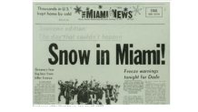
It made news all over the world. Even Johnny Carson did a joke about it in his monologue that night. People who had never seen this before pointed up to the sky as if they were seeing a flying saucer. A local hardware store, in jest, put up a sign stating: “Today’s Special-Snow Shovels."
“YES, THAT IS SNOW ON THE RADAR”. “NO, IT CAN’T BE.”
That was the conversation between me-the loudmouth intern, and my supervisor of the Radar & Public Service section of The National Hurricane Center in Miami. I was on the midnight shift, and started seeing reports of snow in North Florida (Tallahassee and Jacksonville) when I came in. Every hour or two, more reports came in as the snow spread southward through the state.
By about 7 a.m., my supervisor came in, just as I was about to do something no one had ever done-make an official report of snow on the Miami radar. Things were primitive back then, using teletype to send information. I had started the report with “R-S-," meaning light rain and snow. But he wouldn’t let me send it.
“We’ve never had snow here-it can’t be snow," he said.
So far, no snow had been observed south of West Palm Beach.
I replied, “But I’m from Pennsylvania. I know what snow looks like on radar.”
Local
Breaking news and the stories that matter to your neighborhood.


It wasn’t long after that when the calls started. It was snowing in the Fort Lauderdale area. Some people were actually screaming at me, as if a monster had broken into their house. “IT’S SNOWING! I SWEAR IT’S SNOWING!” After a few calls we were convinced it was really happening. Then the calls started coming in from the Miami area-as far south as Homestead. Snow was even reported in Freeport in the Bahamas. By then, I was allowed to report it officially on radar. But it never did snow officially at Miami International Airport, so the record books need an asterisk.
WHAT WEIRD PATTERN CAUSED THE WEIRD WEATHER?
It had to be an extreme pattern-after all, this was unprecedented. Here is the upper-air map from that time, along with the headline as big as if World War III had started…..
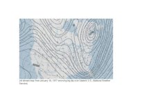
The now infamous Polar Vortex had dropped near Maine. But the most important feature is the sharp change from that LOW in Maine down to Florida. Upper-air winds flow along those lines, so a flow from the north from Canada to Ohio to Georgia quickly changes to a flow from the southwest just off the Florida coast. This is known in meteorology as a “sharp trough," and we rarely see anything so extreme. This pattern not only brought severe cold all the way to Miami, but also allowed precipitation to fall along a narrow band in Florida. A typically strong cold blast coming into Florida usually brings dry weather. Only an extreme pattern could lead to the snow.
This may happen again one day in the future. But it hadn’t happened in about 100 years before the event, and hasn’t happened in the 40 years after it.
