
IT’S OUR TURN, NOW (WITHOUT THE FLOODS)
Remember when we had those ten straight dry, sunny days last month? While many of us were enjoying that stretch of weather, it was day after day of rain in Louisiana and surrounding states, causing record flooding. It’s known as a Blocking Pattern, and it’s our turn to get stuck in the cool, cloudy, and damp part of one.
IS THIS UNUSUAL?
No. We have seen blocking patterns in the upper atmosphere as long as we’ve seen maps of the upper atmosphere. They are more common in some parts of the year and more common in certain parts of the world. If we didn’t have blocking patterns, that would be unusual.
WHAT IT MEANS FOR US
In this case, the cool, cloudy, damp weather will continue through at least Friday. Temperatures may not even reach 60 in many parts of the area (our normal high is 70). I don’t expect a lot of rain to fall-no flood threat or anything close to it. But we will see fog and some drizzle at times during the next two days. By Friday, the center of the upper-air low will be right over us, so that may be the day when we see more hours of rain. There could even be some coastal flooding, due to the persistent wind off the ocean plus the new moon (which raises tides all by itself).
Here is that upper-air map for Friday. That’s pretty extreme for May.
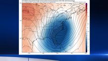
The blue areas are below normal pressures, with the center of the upper low right over Delaware Bay. And here’s the surface map for the same time:
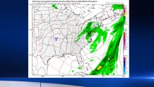
That’s a map that shows a rainy and chilly pattern, especially for May.
WHEN IS THIS BLOCKING PATTERN GOING TO BREAK UP?
It takes a while for blocking this strong to break up, and that’s been the case this spring. Look at the upper-air pattern for Thursday:
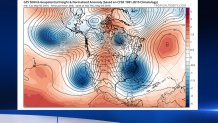
Not only is there a strong LOW in the Eastern U.S., there’s another one along the California coast. And then there’s a HIGH pressure ridge in-between. Does the U.S. pattern look familiar? It looks like the Greek letter Omega:

OK, it may not look exactly like an Omega to some of you, but meteorologists have been using the term for ages.
This particular Omega Block will be breaking up over the weekend, just in time to allow for some sunshine and mild temperatures to return. And the pattern by the middle of next week will look much different than it does now.
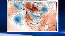
That’s a more “normal” pattern, which will allow much warmer air to move in. And lo and behold: temperatures near 80 are in the forecast by Wednesday.
