
The expression “March comes in like a lion” may go back as far as 1732. It makes sense meteorologically, since early March is still winter, and huge temperature contrasts across the country can lead to some big storms.
By the end of March, the bitter cold of winter has usually retreated. Snow is much less likely in our part of the country. Average high temperatures go up from 48 on March 1 to 58 on March 31. We even have days that can get into the 80s late in the month.
Of course, weather doesn’t necessarily work on schedules. "Normal" is just the average of extremes, not what we expect for any given day. But this year, the "lion" part is coming just as we start March.
The Storm — What Do We Call It?
It’s sure not a classic "Nor’easter." As Benjamin Franklin figured out back in 1743, a storm was moving TOWARD the Northeast (up the East Coast), but the wind was blowing FROM the Northeast. So he concluded that storms have a circulation, which was a big deal back then. (Here’s a good explanation of how it happened.)
This week's storm is going to give us winds from the Northeast at times, but won’t be traveling to the Northeast. It’s going to track to the East, or even Southeast. This is rather unusual, but sometimes happens at this time of year. Let’s see how the storm evolves. First, the current map:
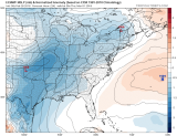
The storm isn’t much of a storm-just a weak area of low pressure on the left side of the map in Oklahoma. The lower the number with the low, the more intense the storm is. Same thing for the number of lines around the low, and how close together they are. Wednesday’s low is 1002 (for those interested, it’s in millibars).
Local
Breaking news and the stories that matter to your neighborhood.


Now, look at just 24 hours later. The storm has moved into Ohio, the pressure has dropped to 995 millibars, and there are many more lines around the low. The more lines, the stronger the wind:
[[475429443, C, 410, 315]]
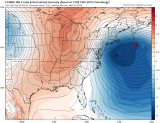
And now look 24 hours later, into Friday night. The low has moved WAAAAY offshore, but the pressure is down to 974 millibars. This is evidence of rapid intensification. As with a previous storm this winter, it can be classified as “bombogenesis” because it has intensified so rapidly. There are lots of lines around that low, and they are bunched together tightly. At this time, our winds could be 30 mph with gusts over 50 mph if this computer model is right:
Storm Problems
1. Rain
By itself, the March Lion storm wouldn’t bring enough rain to cause flooding. But February has been one of the wettest months on record in much of the area, so even the expected 1 to 2 inches could lead to localized flooding. The heaviest rain should fall Thursday night into Friday morning
2. Wind
The wind around this storm could be the strongest of any storm we’ve seen this winter. Some computer models show gusts well over 50 mph late Friday and Friday night from the Philadelphia area to the shore. That could lead to some wind damage.
3. Coastal Flooding
A storm off the coast combined with a full moon leads to a coastal flood threat nearly every time. There are still some uncertainties related to how long onshore winds will last, which is a critical part of the threat. Heavy rain also adds to flooding at shore points in situations like this.
4. Snow
Temperatures near the ground are much too warm for snow, and there isn’t much cold air to our west. But in these springlike storms, the cold air comes down from aloft. Heavy rain can change to heavy, wet snow in a snap. This is most likely to happen in the Poconos, where accumulation is likely. But it’s also possible in higher elevations in the Lehigh Valley and the Philadelphia suburbs. And, if the upper-air part of the low tracks just right, it could even snow for a while in other parts of our area. But, just like our last storm, it would likely melt on the roads as it falls.
The Bottom Line
This “March Lion” storm will surely bring rain, gusty winds, and some coastal flooding. Higher elevations will get wet snow as the storm passes. The storm should move out in time to give us a rare dry weekend. But it will still be windy Saturday. Stay tuned for updates on this multi-threat storm.
