
What to Know
- A First Alert for heavy morning rain, localized flooding and coastal flooding.
- The storm is putting a damper on early holiday travel and the start of the final shopping weekend before Christmas.
- Sunday is the best day of the weekend to travel or get last-minute Christmas shopping done.
Drenching rains have put a damper on early holiday travel and the start of the final shopping weekend before Christmas.
"Weather is just going to compound any mode of travel over the next few days," AAA Mid-Atlantic's Jana Tidwell said.
The NBC10 First Alert Weather Team has issued a First Alert for heavy morning rain, localized flooding and coastal flooding until 9 p.m. Friday.
"It's going to impact millions along the East Coast, causing significant travels delays," NBC10 First Alert Weather meteorologist Steve Sosna said. "It's a pack your patience kind of situation."
The rain started sporadically in some areas Thursday afternoon before the storm gelled overnight bringing drenching downpours to much of the area.
Here is a timeline so you can plan that trip to grandmother’s house or to pick up grandma’s gift accordingly:
- Midday Friday: Scattered showers, less windy
- Friday afternoon through evening commute: A chance of showers, a slight chance of thunderstorms
- Early Saturday morning: Showers end, gusty winds return
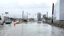
There was some localized flooding early Friday and minor flooding along creeks and rivers with the worst of it hitting the eastern Branch of the Brandywine Creek. A Flood Warning went into effect Friday morning into early afternoon for areas around the Brandywine Creek in Delaware and Chester counties. Flooding concerns also led to Flood Warnings Along the Rancocas Creek in Burlington County and the Neshaminy Creek in Bucks County.
- Click here for the full list of weather alerts.
Rain even caused flooding near the 76ers Fieldhouse in Wilmington, Delaware Friday morning. Wilmington police urged drivers to avoid the area.
There is no threat of snow as high temps Friday, despite the official start of winter, pushed into the 60s.
Local
Breaking news and the stories that matter to your neighborhood.

The springlike storm is part of a system that is affecting millions of people up and down the East Coast. "It’s a high impact storm for much of the East Coast," Steve said.
If you have a flight, check your status before heading to the airport as the storm in other popular tourist destinations from Florida and Atlanta (where it was strongest Thursday) to Washington, D.C. through Boston (where the storm is expected to hit hardest Friday) could leave flights grounded or delayed. Expect slow driving conditions and possible train delays as well.
If you plan Saturday to check the final items off your Christmas list or do some grocery shopping for the Seven Fishes, strong winds gusting to 40 mph could make for a tough walk through the store parking lot.
Everything calms for a sunnier Sunday, so, that may be the day to pick up all your last-minute Christmas needs.
"Sunday is the pick of the weekend," Steve said.
The Eagles game should be sunny with temperatures in the middle 40s. Go Eagles, beat the Texans!
What about Christmas? Possible light rain and/or snow showers could move through before dawn Christmas Eve but nothing major is expected. Christmas Eve and Christmas day will be partially sunny with highs in the low 40s.
Stick with the NBC10 First Alert Weather Team on air and in our app throughout the long holiday weekend for any developments and changes to the forecast.
