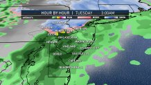
A First Alert weather event issued for the Lehigh Valley, Berks County, and the Philadelphia suburbs of Upper Bucks, western Montgomery, and northern Chester counties expired early Tuesday.
The First Alert was for a wintry mix of snow, freezing rain and sleet that will pass over these neighborhoods.
The good news is that the period of precipitation was brief, and accumulation totals were very low. A light coating is possible. This left behind some slippery roads, but not for long.
Temperatures will quickly rise Tuesday as a warm front approaches the area.
Ahead of this front, the air will be cold enough to support the wintry mix in the northern and western edges of the greater Philadelphia region.
The mix will began just past midnight and lasted through around 5 a.m.
Local
Breaking news and the stories that matter to your neighborhood.
Southern portions of the Pennsylvania suburbs will primarily see rain showers as the moisture slides through. Areas along the Interstate 95 corridor, southern Delaware and at the shore should expect rain showers as well.
Once the precipitation ends, the temperatures will quickly push into the 40s and low 50s. This will melt any icy conditions left behind.
If you’re an early morning commuter in the northern neighborhoods, you may want to leave extra time for slow driving, or just wait for improved driving conditions.