
IN THE GOOD OLD DAYS
I’ve been going to the Jersey Shore since the 50s. My parents have lived there full-time for about 20 years. So I’m pretty familiar with how things have changed. The bottom line: IT FLOODS MORE FREQUENTLY AND MORE SEVERELY. Ask anyone who lives near the back bays in Atlantic City, Ventnor, Margate, Ocean City, Sea Isle City, and more, and they’ll tell you the same thing.
In the old days, it would take an actual storm to produce flooding. It could be a strong nor’easter or a brush with a hurricane, but floods were not frequent. The blocking pattern last week is a perfect example of how easy it is for flooding to occur at the Shore.
LESS THAN A FOOT?
In the National Weather Service discussion early last week, there was a special section on coastal flooding. Tides were going to be high regardless of any storms, simply due to the coming new moon (tides get higher near the full moon and new moon). There’s also a thing called "Spring Tides," when the Earth, sun and moon are in a line. Their gravitational pulls reinforce each other, and the resulting high tides are even higher than others during the year. But still ...
The NWS statement:
THE FRIDAY EVENING HIGH TIDE CYCLE WILL ONLY NEED A SURGE OF .7 FEET
Local
Breaking news and the stories that matter to your neighborhood.


TO RAISE THE WATER LEVEL TO MINOR (flood) THRESHOLD.
So, wait a minute! Are they saying that the "storm" only has to raise the water level by 0.7 feet to create coastal flooding? Less than ONE FOOT? Yup, they are.
SEA LEVEL RISE HAS BEEN BIGGER AROUND HERE
The sea level doesn't rise equally across the world. It's simple physics: warm the oceans, and sea level will rise. It’s called "thermal expansion."
And there’s no doubt the sea level all along the East Coast has been rising in the past century. Here’s what the Atlantic City graph looks like:
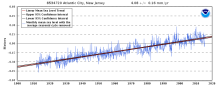
New Jersey's sea level rise is about more than the general warming of the oceans that is affecting coastlines all over the world. It's been rising faster in our area due to "subsidence" (the land sinks a bit), plus changes in the nearby Gulf Stream (possibly related to global warming as well). It all adds up to trouble: sea level has risen about 8 inches in Atlantic City since 1970 alone (about 15 inches since 1900). That doesn't seem like much, but look at what it's done. It floods with a wimpy, barely-there nor'easter! And that's NOW. What happens in the future, as sea level continues to rise?
"WE AIN'T SEEN NOTHIN' YET"
In the 1990s, Atlantic City reported fewer than 10 days a year with at least minor coastal flooding. By this decade, the number is close to 30. And with projections of continuing sea level rise (there’s nothing to stop it), the frequency of flooding will become astonishing.
The list below shows how many days with coastal flooding ...
1. Currently
2. In 2030, and
3. In 2045
For Cape May, NJ
1. About 30
2. About 125 days
3. About 300
For Atlantic City, NJ
1. About 30
2. About 90 days
3. About 240
For Lewes, DE
1. About 25
2. About 90 days
3. About 220 days
We’re only talking about 30 years from now, when it will flood at high tide about SIX days every week in Cape May, and FIVE days a week in Atlantic City!
