
LESSON #1: TRY TO IGNORE THE LINE AND DOTS
The below map shows the official forecast from the National Hurricane Center (NHC) at 11 a.m., Sept. 6. In the weather business, this is considered a remarkably accurate forecast. The “cone of uncertainty” covers every part of the actual track during the coming five days. If only all of their forecasts were this good.
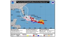
But was it good enough for some people? No. Because they looked at the solid black line and the dots representing exact forecast points. To some who lived along the Florida west coast, it meant that they "were probably in the clear." As we know, Irma tracked right up the west coast, giving them the hardest blow. But they shouldn’t have been surprised by that (or delayed evacuating), because THEY WERE CLEARLY WITHIN THE CONE. Maybe one day, NHC will be able to forecast so precisely that a four-day forecast can have a cone only a few miles wide. In the meantime, all of the Florida Peninsula was in the cone, and all of the Florida Peninsula was slammed. Kudos NHC! (Later forecasts were even better).
LESSON #2: THE EUROPEAN MODEL "WINS" AGAIN!
If you read my blogs regularly, you might think that I’d be tired of writing that the European computer model beat the U.S. model again. But I’m not tired of it, and I won’t stop writing about it until more meteorologists accept the FACT that the EURO is better-period. Not always better, but more often than not.
I was part of a panel discussion on hurricanes last week, along with three other meteorologists. We probably had close to 100 years of combined experience, yet I felt obliged to mention the EURO superiority several times.
Local
Breaking news and the stories that matter to your neighborhood.
“But what about the predicted snowstorm last year?”
“But it’s not better all the time.”
“But it had a wrong forecast for Irma”. (A specific time was named)
I’ve had arguments with many other meteorologists over the years. This is especially true of those who work (or have worked) for the National Weather Service. Sure, there is a tendency to want to defend "the home team." But do we want to make the best forecast or not?
Here are the actual statistics for Irma from a great article on the subject (from Aug. 30-Sept. 8):
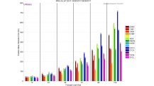
This takes a little explaining, but the University of Albany has done us a great service. This is not about opinions. It is about numbers. Big numbers. Big, as in the errors of the U.S. model, the GFS (in this case known as the AVNO-in brown). Each bar represents a different model (including the “official” forecast from NHC-OFCL), and the “consensus” of models (TVCN). The errors are in kilometers, so I’ll translate to miles.
The error in storm location was (about):
48 hours 72 hours 96 hours 120 hours (5 days)
EURO 47 miles 59 68 109
OFCL 62 93 130 186
AVNO 78 124 193 295
That’s not even close. If NHC just took the EURO verbatim, they would have done better. In most cases, though, even though the EURO is the best model, NHC is able to beat it, due to their world-renowned knowledge and experience.
Was this a fluke? Nope. Look at how much better the EURO did with Harvey.
Not only was it superior with the track position, it predicted up to 53” of rain for parts of Texas. Sound familiar? Amazing!
LESSON #3: REPORTERS WILL KEEP GOING INTO THE STORM
Along with much other second-guessing after a hurricane, we always find complaints about all the reporters and meteorologists who went out in the middle of a hurricane and got blown around. Irma was no exception.
Since I started the storm chasing at The Weather Channel way back in 1985, I have followed this issue closely. News reporters had been the ones going out into the storms prior to that. But I felt that a meteorologist could understand what was happening at the scene, and explain it better as well. And it is still true that The Weather Channel meteorologists do a phenomenal job in using their storm knowledge.
But why should any news person be out there?
Yes, it makes for “great TV." Viewers are entranced watching the ongoing drama of the storm. The high ratings prove it. Some might be waiting to see if the reporter is blown over by the wind, or even worse. But, rather than encouraging others to go out in the storm, I think it reminds viewers of the dangers of being outside. And it helps keep them indoors, where it’s safe. Plus, the more people in the path of the storm watch, the more likely they are to heed the warnings.
The proof is how few fatalities happened despite major destruction. It was the combination of the accurate forecasts, media warnings, first responders, and visual proof of the storm’s dangers. Criticism? Fine. It was worth it.
LESSON #4: THANK YOU, TOUGH FLORIDA BUILDING CODES
Many people seem to be surprised at the lack of wind damage to homes from Irma. I wasn’t. Once Irma’s maximum winds dropped from 185 mph at its peak to 130 mph at landfall, a lot of Florida homes were bound to survive. Why? Florida has the toughest building codes in the country, and they probably saved thousands of homes and billions of dollars in damage. They may not have made it if Irma had stayed a Category 5, though.
After Hurricane Andrew devastated an area just south of Miami in 1992, the state upgraded building codes. New homes had to withstand higher wind pressure, have stronger roof fasteners, plus impact-resistant windows.
The roof and windows of residences are the keys to building survival. Something as simple as stronger ways to attach the roof to the rest of the building costs little, but makes a big difference. And the requirement to have impact-resistant glass or storm shutters protects windows. That’s pretty costly, but it can prevent so much damage that the insurance industry is convinced that it’s worth it. Just a small part of a roof blowing off, or windows broken let water to get into the home and ruin everything. The high rises, with shutters required, suffered little or no damage.
LESSON #5: HARVEY, IRMA, AND CLIMATE CHANGE
I’ll address this in much more detail in a blog later in the week. But let me say these things for now:
No, it’s not too soon to talk about it. Is it too soon after the car accident for the police to question those involved?
Just because we don’t know everything doesn’t mean we know nothing. Those who don’t at least suspect that climate change had something to do with the record rains of Harvey or power of Irma, may be fooling themselves.
