
What to Know
- Life-threatening cold air will freeze the region over a 60 hour stretch lasting through Sunday morning.
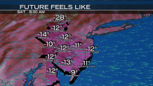
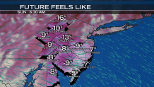
- Wind chills will make it feel between minus-10 and minus-20 degrees over the weekend.
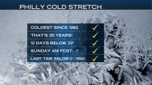
- Philadelphia could set a record low temperature on Saturday or Sunday. It has not been zero degrees or lower since 1994.
If you walk outside in Philadelphia on Sunday and wonder when the last time the air felt so cold, you'd be right to guess it's been awhile.
The low temperature in the city is forecast for 1-below-zero Fahrenheit on Sunday morning, which would make it the first time in nearly 24 years that the thermometer dips to zero or below.
That's the worst of an expected 60-hour cold snap that will make the Delaware Valley feel more like the North Pole. Following the powerful snowstorm Thursday, the region already looks like the tundra.
The new weather woe also come equipped with brutal winds. Even before we started thinking about a sub-zero Sunday, wind gusts made the air feel as low as minus-12 in Philadelphia and minus-30 in The Poconos. Saturday night saw temperatures in the teens and single digits in parts of the area.
At those levels, hypothermia and frost bite can set in quickly, so it's important that people (and their pets) limit time and activities outside.
The frigid air will last for more than 60 hours and we could set a record low temperature of zero degrees or below this weekend. Wind chills could again dip to minus-20 degrees. The last time the official temperature in Philadelphia was zero degrees or below was on Jan. 9, 1994 when Philadelphia International Airport recorded minus-5 degrees.
By Sunday afternoon, the cold air will break away from dangerous territory.
Local
Breaking news and the stories that matter to your neighborhood.

This protracted Arctic blast comes on the heels of the powerful, 1,000 mile wide nor'easter that underwent "bombogenesis" in the Atlantic Ocean. The storm lashed Atlantic City, New Jersey and surrounding towns with blizzard conditions.
Light, crystalline snow formed drifts more than a foot high in some towns. Official snowfall readings ranged from 17-inches in Cape May Court House, New Jersey to 4.5-inches in King of Prussia, Pennsylvania. Gusty winds will continue to blow snow down streets through Thursday night making it appear as if it's still snowing.
Any snow left over is expected to quickly harden into a sheet of ice. If you try to shovel, take extra care not to overexert yourself. Watch your step while walking down the sidewalks as well as rock salt isn't as effective at such low temperatures.
TIMING
Dangerous Cold – Thursday night through Sunday morning
FORECAST
SUN: Partly sunny, still bitterly cold. Low -1 / High 22
Stay with the NBC10 First Alert Weather Team for the latest details on the dangerous cold.
