
Won't Take That Much to Be the Biggest
It’s no secret that this winter has been a little short on the snow side. Okay, maybe a LOT short. This is especially true for areas north of Philadelphia. Here are some seasonal snow totals so far in comparison to “normal”:
Allentown 2.9 inches -13.0 inches
Atlantic City 7.2 inches -1.2 inches
Philadelphia 6.0 inches -4.2 inches
Wilmington 4.5 inches -5.2 inches
It’s obvious that Allentown has the most catching up to do. And it looks like they’re going to at least come close to normal. Philadelphia is likely to be very close to normal after this storm.
The Track & Speed Will Limit the Storm
This is not going to be another “big one," like the one we had last January 22-23. Philadelphia had 22.4 inches over a two day period. That was dwarfed by the Allentown total of 31.9 inches! We’ve had a few monster snowstorms in the past decade, and the one last winter ended up as No. 4 on Philadelphia’s all-time list. Nos. 2 and 3 occurred during the record winter of 2009-10.
Those storms had a combination of factors that helped make them big:
*Lots of moisture from Gulf of Mexico and/or Atlantic
*A track from the Gulf or up the East Coast
*”Blocking patterns” that cause the storm to move slowly
This week’s storm won’t have any of those three factors.
The track of this one is straight from west to east. Gulf of Mexico moisture won’t have much chance to help enhance the snowfall. And the track will be too fast, limiting the number of hours of significant snow. [[413078853, C]]
So, there is a limit on the snowfall, even in places where nearly all of the precipitation will be in the form of snow. In Philadelphia and points south, it should start as rain with temperatures well above freezing. That means southern parts of our area will see less total snow than northern parts.
Local
Breaking news and the stories that matter to your neighborhood.


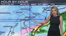
The Latest computer Guidance
It’s called “computer guidance," not the “computer bible." The data and maps that come from the various computer models are designed to help guide us. Just using data and maps makes someone a “modelologist," not a meteorologist. Snowfall is still one of the hardest and most complex things to forecast, especially when some of the precipitation will fall as rain.
For example, what will be falling when the precipitation is the heaviest? It’s pretty obvious that if the answer is snow, it could be falling at 2 inches per hour for a while. If it happens to be rain, that will really cut down the snow totals. Especially when we’re going from record warmth to snow, how fast cold air moves in will be crucial.
Here is what the “average” model is showing for the storm. First, as it approaches at 11 p.m. Wednesday (still dry and warm here):
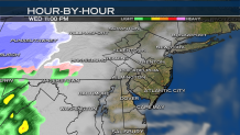
Then a mere SEVEN hours later:
The blue is the heaviest snow. Yellow is heavy rain. And the LOW track has gone from near Washington, D.C. to Cape May. This should be the peak of the storm, with the heaviest snowfall and lowest visibilities.
Now, only SEVEN hours later:
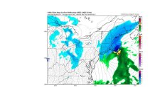
The LOW itself has raced offshore to just south of Cape Cod, and this model shows the snow completely gone from our area. Clouds should be thinning and any snow on roads should be melting by this time. As a result, I expect travel conditions to improve a lot during the afternoon.
But try to shovel the snow while it’s daylight. Strong winds will be bringing in very cold air overnight, causing any slush to freeze.
The Amounts?
I expect snow amounts to range dramatically across our area. At the Jersey Shore and Southern Delaware, where most of the precipitation will be rain, just about all snow would melt as it fell.
Farther north, with some rain, and some snow with temperatures above freezing, amounts should range from about 2 inches south to 6 inches just north of the PA turnpike. And the area north of the turnpike should range from 6-10 inches. The highest amounts are likely in higher elevation areas that usually get more than the surrounding areas. [[413108463, C]]
The NBC10 First Alert Weather Team's forecasts are the most accurate in the Philadelphia area, says WeatherRate.com. The team brings 80 years of combined forecasting skill to NBC10 viewers.
