
This is a TOTALLY different type of storm than the one that mainly missed us and clobbered New England earlier this week.
This one already has developed; already has a lot of moisture; and all computer models agree that it will significantly affect our area.
But there is still a lot of uncertainty about how much snow will fall -- mainly because of the question of rain vs. snow.
THE BASICS
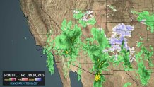
The center of the storm is actually near Phoenix, AZ, site of the Super Bowl. And precipitation covers hundreds of miles around it:
WHY THE TRACK IS SO IMPORTANT
The storm will re-develop in the middle of the country and head east. We often talk about “track” with storms, but this one is even more critical.
This map shows the storm track from Sunday at 7 a.m. (the "L" with 1012 above it, near Kansas City.) The next "L" position (with the blue 1007 above it) is near Cincinnati at 7 p.m. Sunday.
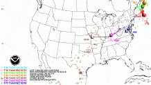
If we would continue that track, the LOW would move just south of Philadelphia. That would put much of our area on the north, or cold side of the storm, leading to mostly snow. With the type of moisture involved, that could produce 6 inches or more.
Local
Breaking news and the stories that matter to your neighborhood.

A couple of computer models show this solution.
But other models have the LOW tracking just north of Philadelphia. That would mean mainly snow N&W of the city, with the highest amounts in the Lehigh Valley and Poconos.
It would probably go from a snowy start over to rain from Philadelphia southward, limiting snow totals. So, the farther south you go, the less snow will fall.
WHY NOT JUST PICK THE MODEL THAT DID BEST IN THE LAST STORM?
If one model was right all the time, we wouldn’t need to see any others, or to compromise with them. Just because one model did “best” last time doesn’t mean it will again. Maybe if it was the same TYPE of storm-but this one isn’t.
An average of the models (as of early Fri. afternoon) would lead to a track right over Philadelphia.
So SOME warm air would come in, leading to a period of rain. Then it could go back to snow as the LOW moves past on Monday.
But how long would the rain last?
THE BOTTOM LINE (AS OF FRIDAY NIGHT)
Snow starts late Sunday afternoon in parts of the area, and becomes more widespread in the evening. Places that stay all snow should get at least 6 inches, with significantly higher amounts possible.
Southern Delaware and Cape May County, N.J. have the best chance of seeing practically NO snow.
The amount of snow will be determined by how much of the storm is rain. Only 30 miles could separate 1 inch of accumulation from 8 inches with this storm, for example.
Only a slight change in the storm track could lead to big changes in snow totals.
Please follow updated forecasts over the weekend, whether it’s on TV, our website, the NBC10 First Alert Weather or NBC10 News apps, Twitter or Facebook.
