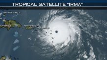
Hurricane “Irma” is now a monster tropical cyclone the size of Texas with category 5 winds of 185 mph.
According to the National Hurricane Center it also holds the record for the strongest tropical cyclone in the Atlantic Basin (excluding the Caribbean and Gulf of Mexico). Atmospheric conditions do not favor weakening and no change of direction is expected before the weekend as it travels west toward Florida. The eye of “Irma” is clearly larger than the U.S Virgin Islands it will pass near and emergency plans have been activated along the projected path.
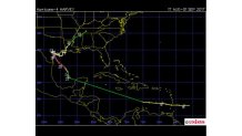
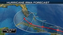
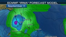
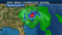
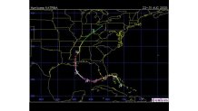
Here is the Tuesday evening satellite image along with the National Hurricane Center cone and both the GFS and European forecast tracks. In a bizarre twist of fate both forecast models currently have “Irma” making landfall in separate U.S. locations, but on the same day…September 11th.
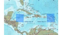
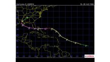
Last week “Irma’s” path was forecast to track through a tiny area known as a “Herbert Box”, one of two regions in the tropical Atlantic that are indicators of a strong hurricane striking Florida. In “Irma’s” case the track has now passed through Herbert Box #1 located over the U.S. Virgin Islands just east of Puerto Rico between 15° and 20° north latitude and 60° to 65° west longitude.
This box is an indicator for storms between June and early September. The 2nd Herbert Box is over the Cayman Islands in the Caribbean between 15° and 20° north latitude and 80° to 85° west longitude and it is an indicator for storms between late September and late October. Both boxes measure roughly 335 miles by 335 miles in size.
Many of the hurricanes that have passed through the Herbert Box #1 form in the far eastern Atlantic like “Irma” did. To qualify as a possible threat to Florida they must have 110 mph winds and track through the box rather than forming outside the box like Katrina in 2005 or crossing the box as a weak hurricane or tropical storm.
Local
Breaking news and the stories that matter to your neighborhood.


Why is box #1 a good indicator for “Irma”? The prevailing winds are towards Florida from this location and there is still ample room for greater intensification before landfall. However, a storm passing anywhere outside this box could still lead to a Florida strike, but the steering winds are less favorable for those storms.
Some of the destructive and deadly storms that passed through the Herbert Boxes before striking Florida were the unnamed storms in 1926, 1928, 1933 and 1935, Donna, Betsy, David, Inez, Cleo, Georges and Francis. One major hurricane that missed the box and barely missed Florida was the giant Floyd in 1999 which turned away from Florida at the last minute. Both Katrina in 2005 and Andrew in 1992, formed outside of the Herbert box yet still struck Florida. In case you are wondering…Hurricane “Harvey” last month did not cross through the Herbert Box.
The two boxes are named after Paul Herbert, a former forecaster at the National Hurricane Center. He looked at hurricanes after 1900 and found a correlation between hurricanes with winds above 110 mph which had struck South Florida after passing through one of these two boxes.
(Hurricane Frances, 2004)
(Hurricane Georges, 1995)
(Hurricane Katrina, 2005)
((Hurricane Andrew, 1992)
((Hurricane Harvey, 2017)