
STRONG STORM MOVING THIS WAY
Look at the spin in the middle of the country! You can see it best in this “water vapor loop."
It takes a strong storm to show a swirl like that. And this time of year, we often see severe thunderstorms on one side of the storm, and snow on the other side. Yes, I said snow-and not just in the mountains. It was snowing in North Texas Tuesday!
A 1, 2, 3 PUNCH
Normally, as a large storm system approaches, there is an area, or line of thunderstorms that will move through our area. In this case, high-resolution computer models show multiple lines hitting Philadelphia in the same day!
Here are forecast maps of the newest, high-resolution model (called the 3km NAM)-at 6 a.m., 11 a.m., and 1 p.m. Thursday. The model clearly shows these as three separate lines. The red colors represent the heaviest rain (and likely thunderstorms).
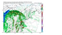
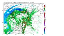
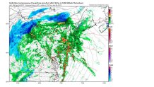
This is pretty unusual. We would get a brief downpour and strong wind gust with each line.
THE FLOOD THREAT
Some parts of our area are much more vulnerable to flooding than others. It’s partly because they have gotten more rain in the past week. Another factor is the type of soil. The sandy soil near the coasts of New Jersey and Delaware can handle a lot more rain than areas far away from the coast. And in this case, Pennsylvania has had a lot more rain in the past week than South Jersey and Delaware.
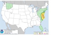
Here is a map showing the amount of rain in a 6-hour period needed to produce flooding:
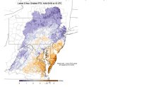
So, parts of the Lehigh Valley and other N&W suburbs of Philadelphia only need AN INCH of rain, and in a couple of spots, even less! That’s not too hard to do. And that is why we have issued a FIRST ALERT for our Pennsylvania counties and Mercer Co., NJ. for the flood threat.
THE SEVERE THUNDERSTORM THREAT
While flooding is much less of a threat for South Jersey and Delaware, those very areas have much higher threats of severe thunderstorms. That means hail and potentially damaging winds. The Storm Prediction Center in Oklahoma has that part of our area in a “Slight Risk” for severe storms. I’ve never liked using the word “Slight” when talking about severe weather. It makes the threat seem trivial. But “Slight” is pretty significant when the SPC uses it.
So, we can expect a few rounds of showers and thunderstorms Thursday-some affecting the A.M. rush, and others even into the afternoon. And that’s why we have the FIRST ALERT for those areas.
THE PHILLIES FRIDAY-NOT SO PHANTASTIC
First of all, Friday will be nothing like Thursday. There will be no severe thunderstorms. There probably won’t be any thunderstorms at all. But the weather won’t be good (that’s putting it mildly).
A look at the predicted surface map for 2 p.m. Friday tells the story. The LOW pressure center is near the PA/NY border. The green area is rain, which goes down into Maryland. And the blue area is (yes, it is) snow. Much of western PA, West Virginia, eastern Ohio, and western New York will be cold enough for snow-even in the middle of the afternoon.
The black lines are “isobars,” lines of equal pressure. The closer they are together, the stronger the wind. And they are close enough to suggest at least 15-20 mph winds. And the temperatures will be in the 40s according to the computer models. So, when you combine everything, you end up with not-very-“baseball-ish” weather. We should even be able to talk about wind chills, which will be closer to 40. With cloudy skies and occasional rain. Yuck. And the rain may not be heavy enough to postpone the game.
So, if you’re going to the home opener Friday (as I am), wear several layers of clothes under your Phillies gear, and have some rain gear with you, too. You’re much luckier if you have tickets for the weekend games, although Saturday night will be on the chilly side. But at least it won’t be raining-or windy.
Local
Breaking news and the stories that matter to your neighborhood.
Stay with the NBC10 First Alert Weather team for the latest forecasts, alerts and updates.
