CHANGES ON THE WAY
We’ve had a lot of days of 90 degrees or higher this summer (27 so far), which is about average for an entire summer. What is unusual is that we haven’t really had any extreme, dangerous heat (temperatures at or near 100). And we’re sure not going to get any in the next week, at least.
A major change in the overall weather pattern will prevent heat from building up in our part of the country for a while. The change from the hot & humid air to more comfort will probably come with a bang, in the form of heavy showers and thunderstorms.
COMPUTER MODELS AGREE ON THIS ONE
Usually, I’m writing about how different computer models are coming up with far different forecasts. This is amazingly true regarding the future of Tropical Storm Danny, but that’s for another blog. But this time, high agreement means higher confidence that the basic forecast will be on target. Not perfect-on target.
Here are the latest forecast maps for total rainfall by Friday afternoon. Notice how similar the amounts of rain are. And the areas getting the most rain are similar, too. These are the NAM, GFS, and Canadian models (in that order) from today. The scale is a little difficult to read, but it is generally showing about an inch in the Philadelphia area, with more to the west and less to the east. But in this case, there is potential for a lot more rain in some localized areas.
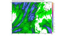
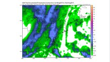
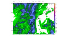
The least amount of rain, on average, is at the shore. And the most (around 2”) is near the Poconos and Berks County. That’s the general picture. Then we try to get into the details.
Local
Breaking news and the stories that matter to your neighborhood.


TIME FOR “TRAINING”?
It’s obviously a dangerous thing to be walking along train tracks. In weather, “training” is potentially dangerous, too. That is when showers or thunderstorms move along the same narrow zone time after time. Some places get a LOT of rain, while others may see none at all.
Another look at the maps above shows a general south to north band of the heavier rain. In this pattern, the actual shower movement is going to be south to north. When you combine an extremely moist air mass with a slow-moving band of showers and storms, it adds up to a potential flooding threat from training. Normally, a north-south line of storms keeps moving, so no one area gets enough rain for flooding. But when showers keep moving from south to north along the line, and the line moves slowly, it can cause trouble.
Keep an eye on the radar in the next 36 hours, whether it’s on TV, your computer, or on your phone. It may give you an extra clue about where the flood threat should be in the next few hours. That’s what our Weather APP is for.