

Both the Old Farmer’s Almanac and Corbyn use solar cycles and sun-earth connections to make their forecasts. Both are secretive about their methods, since this is a profit-making business. Both make spectacular claims of accuracy without publishing anything to verify those claims. But BOTH were right about this severe winter, even scaringly so.
Could it be as simple as looking at the sun? If it were, wouldn’t everyone do it? No one wants to put out a bad forecast; we look for ANYTHING that can help us be more accurate. So, let’s take a look at the sun, and sunspots.
(CAUTION: I AM NOT AN EXPERT ON ASTROPHYSICS OR SOLAR ASTRONOMY. HARDLY ANYONE IS.)
Any 2nd grader knows that the sun is related to temperatures on earth. But variations of the radiation from the sun to earth change very little over time. Could those small changes lead to significant changes here?
The correlation of sunspot activity with the earth’s temperature happened a long time ago. The “Little Ice Age”, from about 1650 to 1850 has been associated with the “Maunder Minimum”, a long period of practically no sunspot activity.
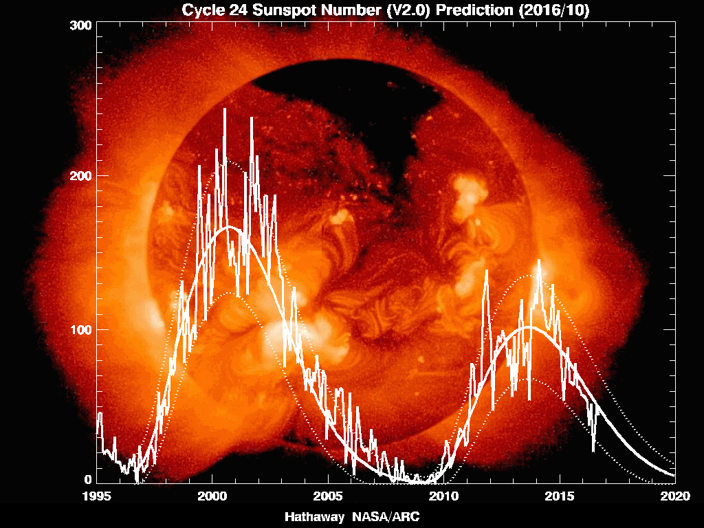
Notice the label on the right side of the plot: “modern maximum”. We have been in an extended period of high sunspot activity for decades. Now look at the latest forecast from NASA on the current and future sunspot cycle (the 11-year cycle has been accepted science for hundreds of years). We have been at a near zero level in 2008 and 2009, and have only recently starting the upward swing. And this cycle (number 24, in solar lingo) is now expected to be much lower than the “modern maximum”.
So, there may be at least some role the sun has made in the recent rough winters, especially in the U.S. and Europe. But does it have to be the reason? One of the things I’ve learned in nearly 40 years as a meteorologist is that simple explanations are usually wrong, or incomplete. The atmosphere is an extremely complex thing, with natural cycles like El Nino and La Nina, the PDO (Pacific Decadal Oscillation), sunspots, and more, combined with sporadic changes.
What else could be playing an important role in these extreme winters (and summers, too-remember, 2010 featured the warmest summer ever recorded in Philadelphia and New York City, among others)? Could global warming be a factor?
(CAUTION: I AM NOT AN EXPERT IN CLIMATE. HARDLY ANYONE IS.)
That sure has become a controversial term. It may even be fighting words in some quarters. But let’s leave our politics aside, and just look at the science. This is not the time or place to go into details, but it’s pretty clear there have been significant changes in the past hundred years (especially the last 30). I don’t want to talk about “global” warming now. To me, it’s more like: “Arctic warming that is messing up weather patterns around the globe”. As predicted by the computer models, the warming has been concentrated in the Arctic. Since there aren’t too many weather stations up there, it is even harder to measure just how much warming has occurred. Here’s a global map of temperature changes in the past decade, taking both land stations AND satellite measurements:
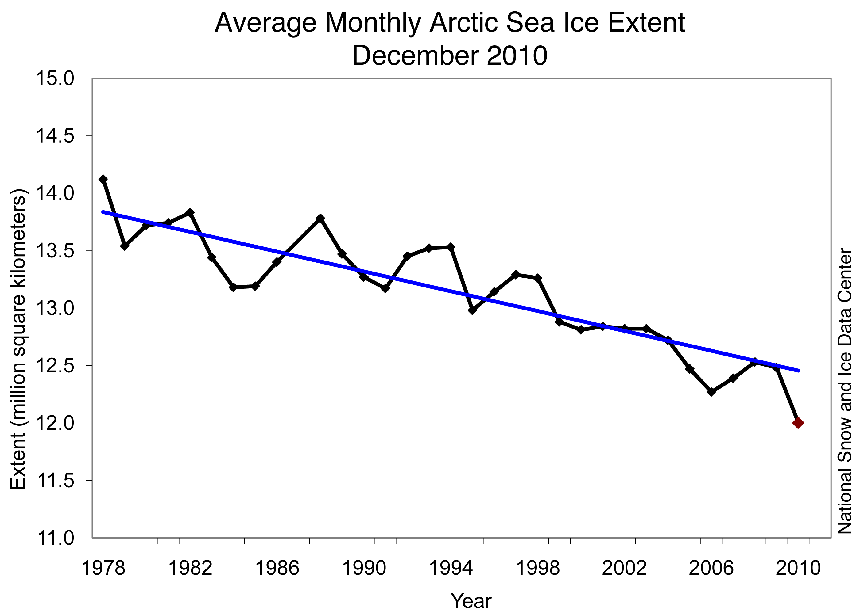
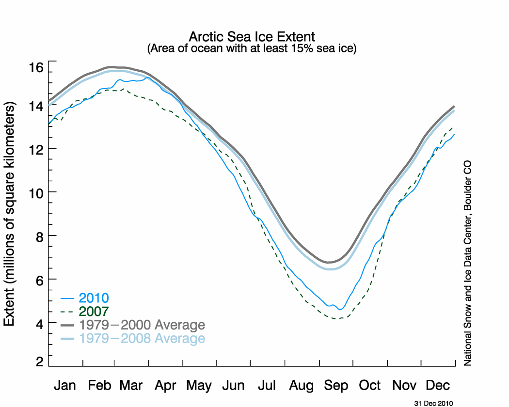
Now, there are some people doubting those instrument readings, so let’s go to the evidence that’s hard to argue with-measurements of ice cover by satellites.
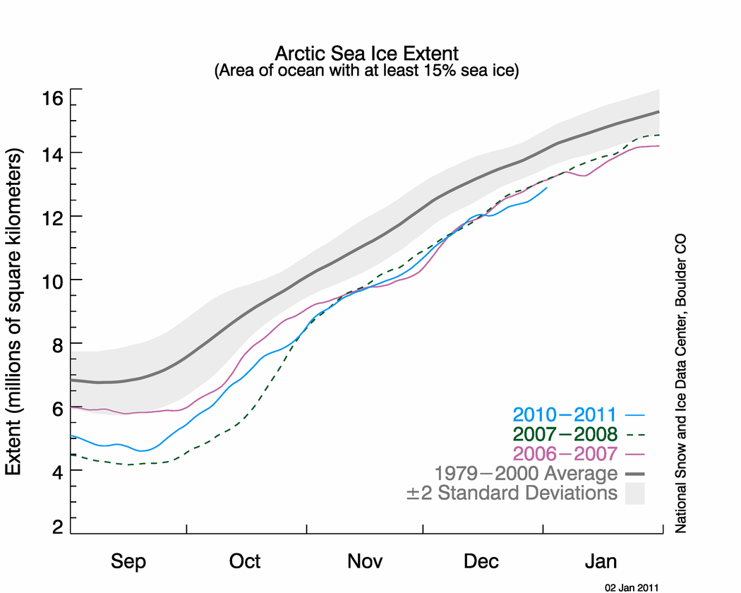
That image does not show big fluctuations, or cycles, or anything ambiguous. Arctic sea ice is retreating at a rapid level (3.5% per decade), and it may be retreating at an even faster pace since the 90s. Global surface temperature trends are not nearly as clear-cut, but this is “smoking gun”-type evidence. And this isn’t just in December. Here’s the graph from September to January:
So, is the National Snow and Ice Center hiding something by not including other months? Nope.
This drop in ice cover is happening much faster than the computer models have been predicting.
Warming in the arctic is even more important than it is elsewhere. Melting ice warms the atmosphere in two ways. First, an area of ice will be colder than when it becomes ocean. The melting warmer water heats up the atmosphere above it. More important, though is the “albedo effect”, which is know as a “positive feedback”. Ice reflects more sunlight back into space than dark ocean water does. A lot more. So, ice melts and warms the atmosphere. A warmer atmosphere melts more ice. More ice melt warms……..you get it.
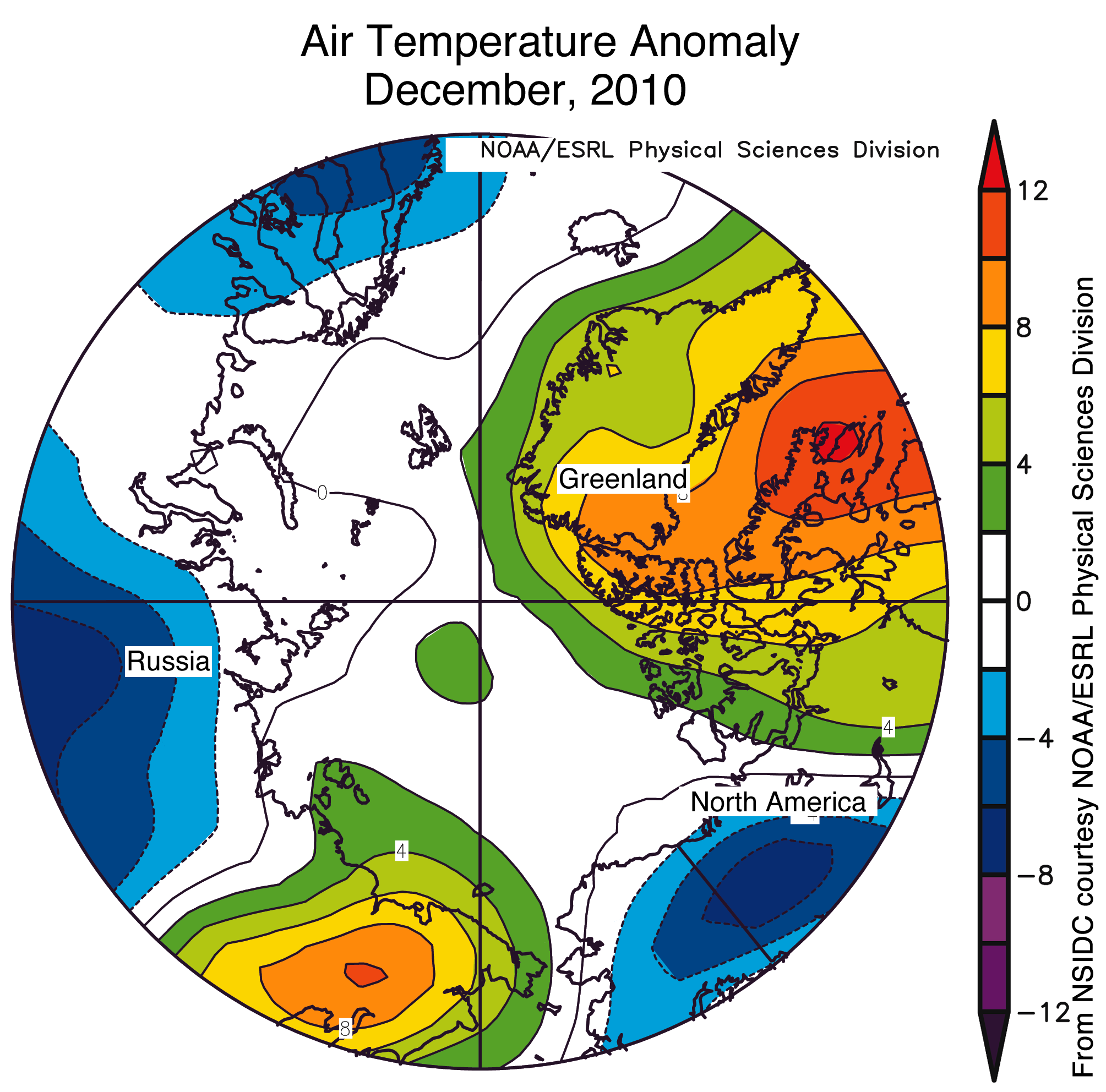
Could it be that the melting ice and general arctic warming led to the exceptional warmth in much of Greenland and northeastern Canada this winter? Here’s a graphic of temperatures compared to normal for December 2010:
Those orange and red colors are up to 20 degrees above normal! For the whole month! Compare that to our very cold December 2010. That month was about 5 degrees below normal.
It’s pretty complicated, but there are many meteorologists who see connections between ocean temperatures that are way above normal and high pressures near the ground and higher up. Take a look at a recent map of ocean temperatures compared to normal. Guess where the biggest warm anomaly is?
And, just in case you think that’s unusual, here’s one of the maps from September 2010:

Persistent areas of high pressure over the oceans are often related to blocking patterns in the atmosphere. And it just so happens that a blocking high near Greenland leads to the infamous negative NAO (North Atlantic Oscillation). Its “cousin” is the AO (“Arctic Oscillation”). Either one or both have been consistently negative since LAST winter-just about every month. We don’t have a record in the past of such consistent (and large) negative values month after month. And it is clear that negative NAO’s and AO’s lead to cold and stormy patterns in the Northeastern U.S. and Europe.
Blocking patterns lead to more weather extremes. They can lead to heat waves as well as cold, snowy winters. They can lead to long-lasting flooding events. Anything that leads to more blocking patterns is going to cause trouble somewhere in the world.
Here’s another way Arctic warming can lead to blocking patterns and other weather problems. The jet streams that steer storms around the world are fueled by temperature contrasts-the bigger the contrast, the stronger the jet. Strong jet streams have less of a chance to lead to blocking-in fact, they can break up blocking patterns. Now, lets say you warm the Arctic a lot more than the mid-latitudes. The temperature difference between the Arctic and the U.S./Europe is less. This would lead to weaker jet streams, which then have a better chance of buckling, which could lead to more extreme weather.
Theories about how Arctic warming can lead to our cold, snowy winters (plus those in Europe) have come from the U.S. (Dr. Judah Cohen, from a company called AER that happened to predict a cold winter this year), to Russian scientists now working at the Potsdam Institute for Climate Impact Research in Germany (who say the odds of cold winters TRIPLE in Europe and Northern Asia due to this warming of the Arctic).
Does it have to be one OR the other: Sun vs. Arctic warming? People on each side of the political spectrum are sure it’s one OR the other. WHY CAN’T IT BE BOTH????????
NEXT: So what does this mean for the rest of this winter, and the next winter, and the next winter……?