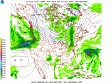
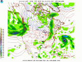
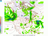
So we’ve mentioned increasing clouds and the likelihood of passing showers tomorrow. While we’re currently under the influence of a high pressure system, a weak cold front passes tomorrow. Keep in mind they’re not widespread, but it does look like Philly Metro could get an isolated shower. I’ve included two models below (long and short range) for a more colorful explanation of the passing showers.
Notice in the long range model (GFS) the front stay mainly north but in the short range model (NAM) it dips a bit lower and brings the scattered showers farther south.
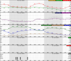
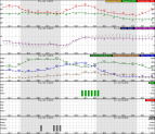
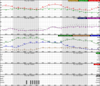
As for tonight, you'll see a few clouds develop as we get a bit of an onshore push, but we'll stay dry. By tonight we'll see some fog developing and it really does look like most of us will have to deal with the fog, but it will be more dense along the shoreline and just WNW of Philly. Below you’ll see three graphs of the expected fog time frames…