
BITTER COLD: A SURE BET
We just finished the second warmest year ever recorded in Philadelphia. December wasn’t exactly balmy, but temperatures did average about 1.5 degrees above normal. Still, that was WAAAAY colder than last December, when we were more than 13 degrees above normal, setting records all over the place.
We had two days with temperatures getting down into the teens, but only one day failed to reach the freezing mark (Dec. 16th, with a high of only 26). We’re about to get into a stretch where temperatures may not get above freezing for FIVE straight days!
Here is the map showing low temperatures Wednesday morning in the eastern half of the country:
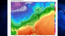
Those are not wind chills, they are actual temperatures. Readings go close to 10 degrees near Chicago, -3 in Minneapolis, and about -18 in Carson Wentz’s home state of North Dakota. And where is that bitter cold air going? It’s going our way (no, it’s not going to get below zero here, but it will be quite cold).
Here is what that same type of map will look like by Saturday morning in the Northeast:
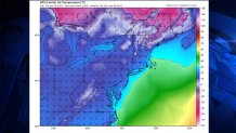
The below zero air has retreated into Canada by the weekend. But look at this map-it shows EVERY state in the lower 48 with temperatures below freezing at the same time!
AND NOW FOR THE SNOW….
It’s been a pretty quiet snow season around here. And we still don’t see any major winter storms in sight. But at least part of our area will be on the northern edge of a couple of storms in the next several days.
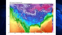
Here is the first one, according to the U.S. GFS model for Friday at 7 a.m.
The LOW pressure off the North Carolina coast isn’t very strong, but there’s enough moisture to spread a little snow as far north as Philadelphia. Obviously, the snow is most likely to fall (and to accumulate) in Southern Delaware and the Jersey Shore. But those blue colors representing the snow are light blue, not the dark blue or purple that would indicate heavy snow.
The second chance at snow is with a bigger storm, with more moisture on Saturday. The storms are so close together that the first one will influence the other. The stronger the first storm is, the more the second one will be suppressed to the south. So, while the GFS model emphasizes the first storm and gives our area nothing from the 2nd storm, other models show the opposite.
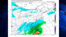
The Canadian model has a weaker first storm and then a wider area of snow with the second one. Here is their map for Sunday at 1pm:
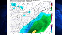
Again, it’s not an intense storm at all, but there’s just enough moisture to spread just far enough north to graze part of our area. As with the first storm, the best chance of any accumulation is in Southern Delaware and at the Jersey Shore.
Obviously, both of these snow “threats” are on the minor side, but in a winter season with so few of these, they become more significant.
