
BAD TIMING
Of all weekends for a Tropical Storm or Hurricane to threaten, Labor Day weekend may be the worst. It’s the last chance for many folks to enjoy the beaches. The ocean is way warmer than Memorial Day or the 4th of July. And September can mean nice, comfortable weather compared to the extreme heat of the heart of summer. And now a tricky tropical system will have an impact. But how much of an impact will it have?
WHAT WE’RE MOST SURE ABOUT
1. Hermine will not be a major hurricane. It will not be another Sandy. A storm tracking from the Gulf of Mexico toward our area must go over land for a long time, which will surely weaken it. On the other hand, Irene, Floyd, Gloria, Sandy, and other names we remember were OCEAN tracks that hit or came close to us.
2. It’s a good thing we haven’t had much rain recently. Anytime a tropical system is predicted to move very slowly (as Hermine will), we look at the potential flood threat. Previous storms that led to serious flooding have come after very rainy periods.
3. The farther you are from the ocean, the less rain and wind you will have by the time it’s over. You also have the best chance of having dry weather at least through Saturday night, and the best chance of clearing Monday.
WHAT’S YET TO BE DETERMINED
1. As usual, the track will largely determine how much rain, wind, and coastal flooding will occur. Major updates of computer models come every 6 hours, and their forecasts have changed each time.
2. Hermine is likely to stall (or move very slowly) off the coast of New Jersey starting Sunday. Exactly where it stalls is unpredictable this far in advance. Even a 50 mile difference in the stall point can lead to big differences in impacts for us.
3. The moon phase will add to any coastal flooding caused by Hermine. Coastal flooding will be higher the farther south the storm stalls.
4. Ocean temperatures are unusually high off the coast of NJ/DE. A slow-moving Hermine could strengthen as it lingers. If it does, places that start off dry Saturday night and Sunday could get rain later.
WHY WOULD IT SLOW-DOWN SO MUCH OR STALL?
Take a look at the predicted upper-air map for Sunday morning:
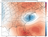
Blue areas have below normal pressures, while reddish areas are the opposite. That unusually high pressure in Southeast Canada will act as a “block”, preventing Hermine from racing out to sea like so many previous storms have.
Below is the result of that block: the Monday map that shows Hermine still offshore (the L), being blocked by a big area of HIGH pressure in the upper right of the screen. So the storm will be spinning around for multiple days, keeping the ocean churned up, causing each high tide to be a problem-perhaps until Wednesday!
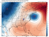
With the addition of higher water levels from the “new moon” (tides are higher with full and new moon phases), the potential for significant coastal flooding increases. The exact wind direction and strength of Hermine will determine just how much of a problem it is.
Local
Breaking news and the stories that matter to your neighborhood.

A TROPICAL STORM WATCH
The National Hurricane Center has issued a Tropical Storm Watch for the entire coastlines of Delaware and New Jersey. The Watch technically only goes until Sunday afternoon, but could be extended well beyond that. The Watch means that Tropical Storm conditions (39+ mph winds) are possible. If it becomes likely, then a Tropical Storm Warning would be issued.
There is a chance that Hermine will lose tropical characteristics as it drifts in the Atlantic. That’s what happened to Sandy, and it led to tremendous confusion about the storm. Many thought Sandy was weakening, just because it wasn’t technically a hurricane anymore. In this case, Hermine could actually become MORE tropical if it spins around enough for long enough. In any event, an already complicated setup could become even more complicated early next week.
If you have any interests at or near the shore, please keep up-to-date on developments this weekend. The NBC10 App is a great way to do that-no matter where you are in the area.
