
TRIPLE THREAT BECOMES DOUBLE THREAT
We have been describing the weather as a "Triple Threat" to the area. The first two have happened: heavy rain Tuesday night, and then another round of heavy rain and wind Friday.
The question was related to Threat #3: Joaquin.
Fortunately, for everyone along the East Coast, one computer model was right, and every other one in the world was wrong.
IN CASE YOU WERE EXPECTING A HURRICANE THIS WEEKEND …
Yes, there were some pretty ominous forecasts for the weekend, IF Joaquin was tracking this way.
Can you imagine how bad things would be IF we added a hurricane to the rain and wind and coastal flooding we’ve already had? One of the anchors mentioned that it looked like we were about to dodge a bullet. I replied: "Actually, it’s more like a nuclear explosion."
Local
Breaking news and the stories that matter to your neighborhood.


Instead, no hurricane, just a windy, chilly weekend, especially Saturday, with winds 20-30 mph with possible gusts up to 50. But the Friday steady rain should taper off to scattered showers.
THE EUROPEAN DOES IT AGAIN
This was the prediction for most of the world’s computer models as recently as Wednesday morning:
The above model was the GFS model, the main one for forecasts beyond 2 days in the U.S. Another U.S. model (NAVGEM from the Navy), the Canadian and the Japan model all showed similar solutions. Even the specialized hurricane models showed the same thing. Here was the HWRF from Wednesday:
[[330524431, C]]
The predictions were similar. And the reasoning was similar. A big blocking pattern in Canada would prevent Joaquin from heading out to sea, and force a curve to the left, slamming the U.S. East Coast.
Only ONE model showed anything significantly different-the now world famous European model. Yes, the same European that was right on Sandy three years ago. It isn’t right all the time (it was the one going for 30”+ of snow in that one storm this winter when we got about 3”).
But it’s track record for East Coast hurricane threats has now reached new heights.
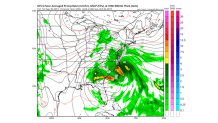
SO NOW WHAT?
Here’s what the “champ” says is going to happen next ... by Monday, it has Joaquin well out in the Atlantic. But the East Coast problems won’t be over:
[[330524451, C]]
The two important weather features aside from Joaquin are that little “L” near the North Carolina coast and the “H” over New England.
The “L” is what could be called the Nor’easter. The “H” is the remnants of the big blocking HIGH that was over Canada. It’s the difference in pressure between the LOW and HIGH that has led to the persistent strong winds from the Northeast (hence the term “Nor’easter”) and major coastal flooding over a stretch of 1,000 miles.
Until we get rid of that big pressure difference, our weather can’t improve much. By Tuesday, the HIGH should take over, and a nice, dry stretch of weather will return.
FOR THE EAGLES GAME
The big pressure difference will continue Sunday, so it will be a windy day for the Eagles game in Washington. Winds of 15-25 mph could affect the kicking and passing games.
There is a chance of some showers, but nothing like what we saw Friday. Temperatures should be in the 60s. That’s a lot better than the way it looked a couple of days ago.
But the EUROPEAN looks like it will win again. It’s been the world’s best for more than 20 years. The rest of the world’s models keep getting better, but just can’t catch up. I’ll go into more detail on that next week.
